


The Tiger Island Fire is under the jurisdiction of the Louisiana Department of Agriculture and Forestry. The Florida Forest Service Green Complex Incident Management Team assumed command of the fire at 1900 Wednesday, October 4, 2023. Prior to this, the fire had been under the command of the Southern Area Gold Team (9/23/23 - 20/4/23), the Southern Area Blue Team (9/10/23-9/22/23) and the Southern Area Red Incident Management Team (9/2/23-9/9/23).
| Current as of | Thu, 10/12/2023 - 11:30 |
|---|---|
| Incident Type | Wildfire |
| Cause | undetermined |
| Date of Origin | |
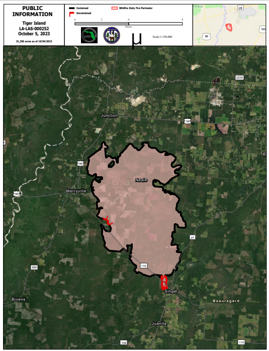
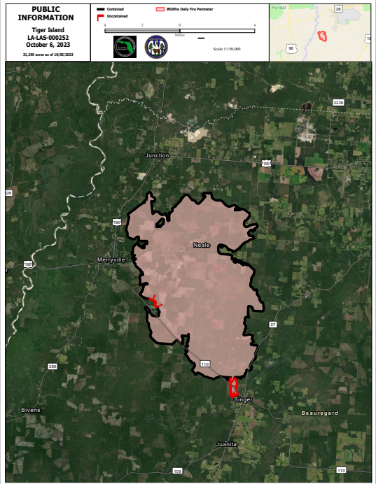
| Location | Beauregard Parish, E of Merryville, LA; S of Hwy 190; SW of Deridder, LA; N of Singer |
| Incident Commander | Anthony Petellat, ICCI, Florida State Green Team |
| Coordinates |
30.° 40' 22'' Latitude
-93° 26' 19
'' Longitude
|
| Total Personnel: | 21 |
|---|---|
| Size | 31,290 Acres |
| Percent of Perimeter Contained | 96% |
| Estimated Containment Date | 10/30/2023 |
| Fuels Involved | Primary Fuel Types: Narrative: |
| Significant Events | Observed Fire Behavior: Narrative: |
| Planned Actions |
Patrol and monitor fire lines and the fires edge. Continue to remove needle cast from fire lines. Mop up hotspots as needed, suppress all fire threats to control lines. |
|---|---|
| Projected Incident Activity |
12 hours: Humidity recovery is expected to be adequate to prevent nighttime fire spread as well beneficial precipitation in and around the fire ground. 24 hours: Mostly clear conditions with no chance of rainfall in the area. Humidity levels will be between 40 to 50 percent with light and variable winds forecasted. 48 hours: A front will seep across the region late Firday, with dry and offshore flow durig the weekend. We could be faced with elevated fire weather, or even Red Flag Warning conditions. Winds will be northerly around 10 to 15 mph with stronger gusts possible and RH values dropping into the 25-35% range. 72 hours: Mostly clear. Not as warm. Lows in the lower 60s. Highs in the upper 70s. North winds 5 to 15 mph. Anticipated after 72 hours: A cold front will sweep across the region late week with dry and offshore flow during the weekend. Elevated fire weather, or even Red Flag Warning conditions will return as RHs drop into the 25-35% range with gusty northerly winds. |
| Remarks |
Florida Forest Service Green Complex Incident Management Team is managing the fire. |
| Weather Concerns | A coastal storm will traverse the northern Gulf today, continually spreading light showers across the area. Any showers will end by this evening, with many areas seeing a wetting rainfall. |
|---|