
Highlighted Activity
Highlighted Media
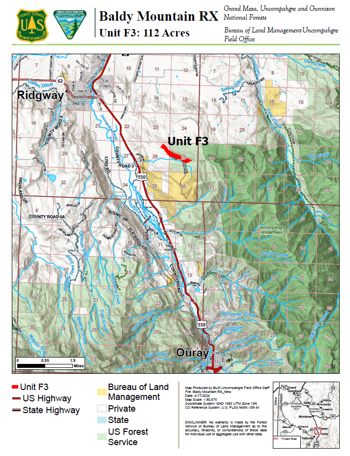
The map shows the boundary of Baldy Mountain Project prescribed fire unit F3, a 112 Acre unit. April 18,2024
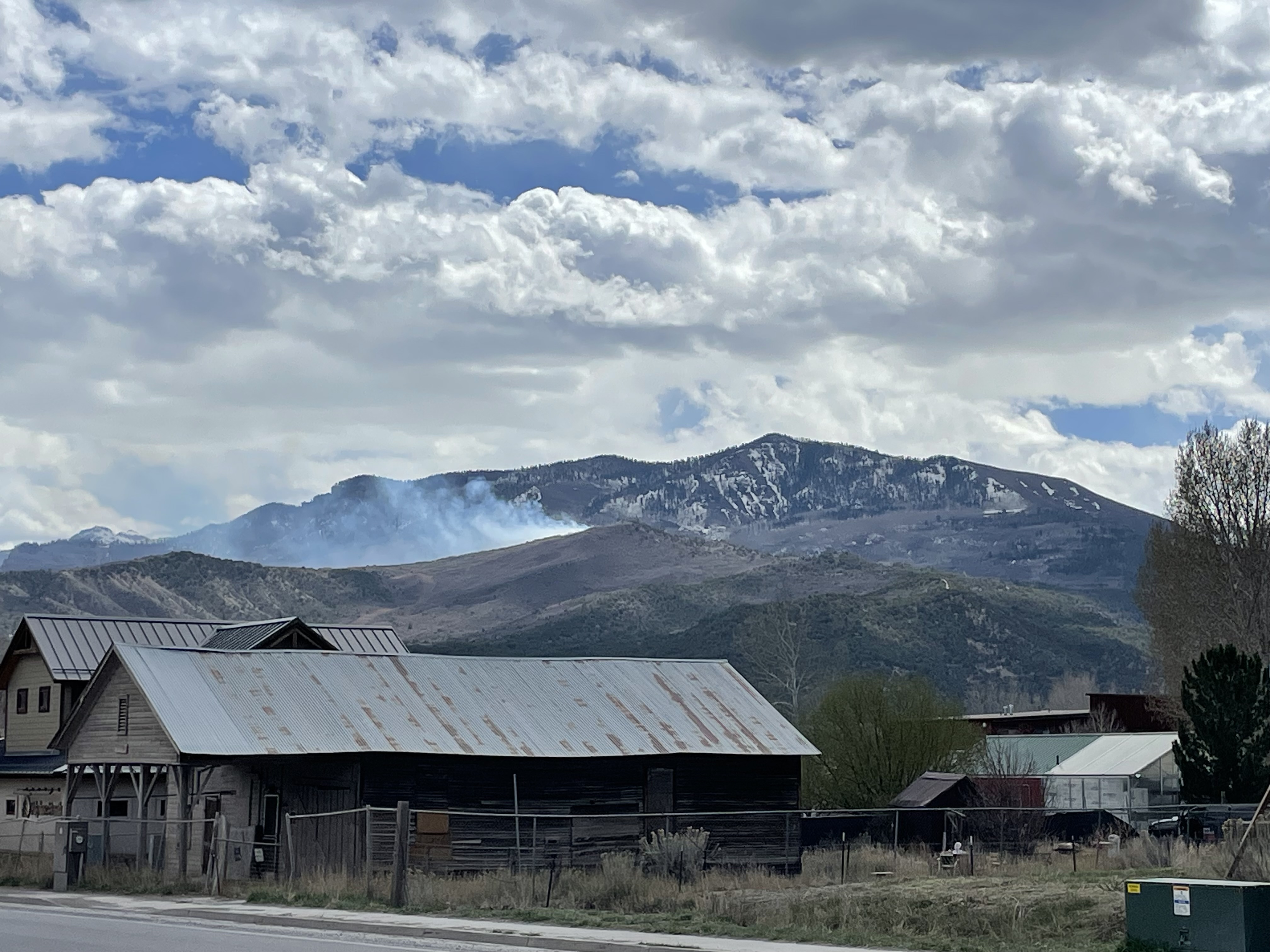
Photo Credit Caroline Kilbane
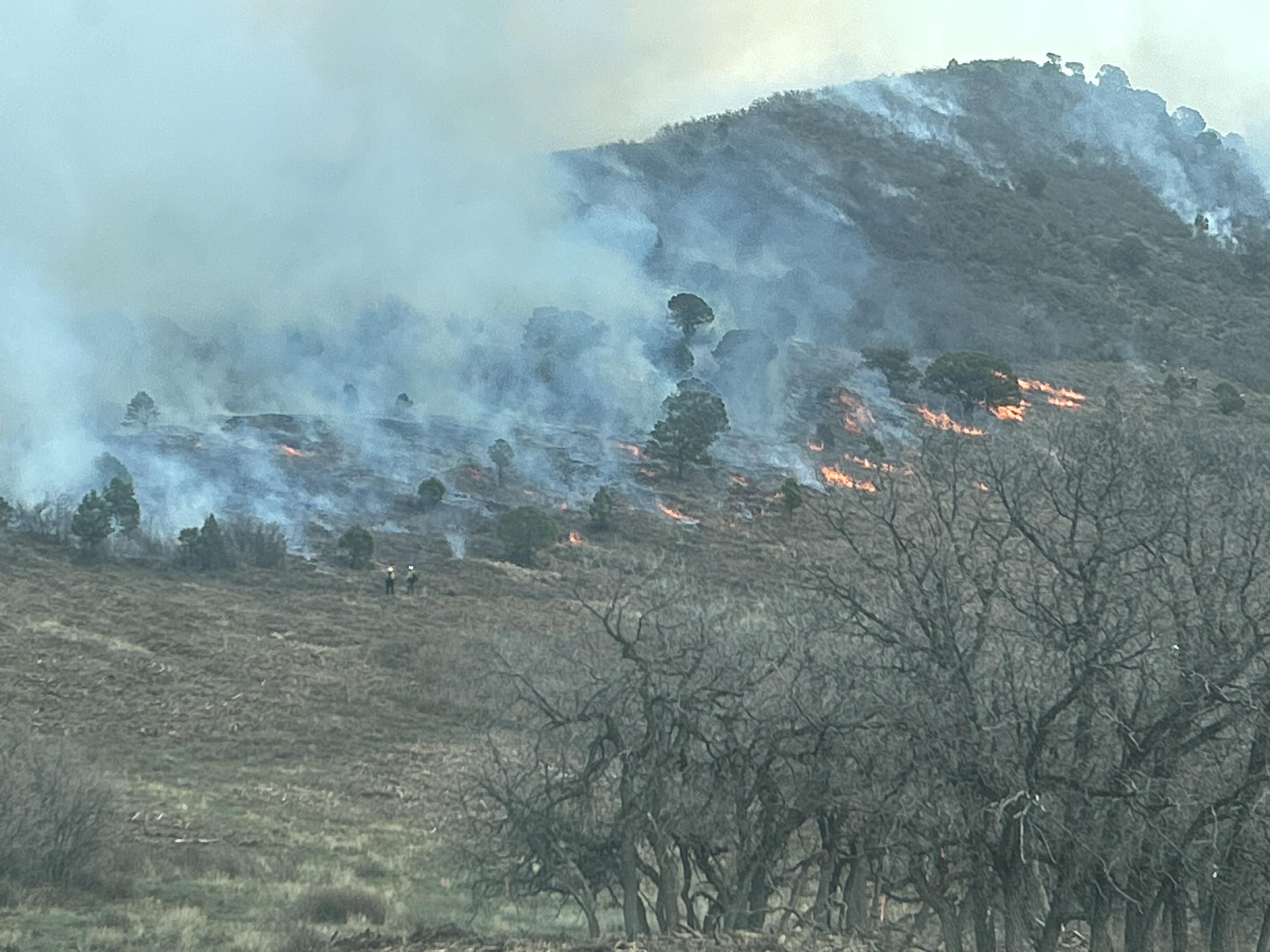
UAS and hand crews ignite understory on 4/23/24
The Baldy Mountain Landscape Resiliency and Habitat Improvement Project is located in Ouray County, approximately 2 miles southeast of Ridgeway, CO and 4.5 miles north of Ouray, CO.
On Tuesday, April 23, 2024, the Ouray Ranger District and BLM Uncompahgre Field Office were able to successfully implement the first of nine planned prescribed fire units associated with the Baldy Mountain Landscape Resiliency and Habitat Improvement Project. The 112-acre unit comprised of masticated oak, pinyon, juniper and aspen. It had been mechanically treated and prepped this past fall under a keystone agreement with the National Forest Foundation. Firefighters used a combination of hand and aerial ignitions with an UAS to conduct the burn. Fire managers state that the effort succeeded in producing the desired effects to meet project objectives.
Project objectives are to reduce the severity of wildfires, protect local communities, create higher quality wildlife habitat and improve the health and resiliency of the landscape. Prescribed burning reintroduces and maintains fire within a fire-dependent ecosystem, helping to stabilize and improve the resiliency of forest conditions while increasing public safety. Once ignited, firefighters will monitor and patrol the units until they declare the fire out.
Planning and implementation for this project have been a collaborative effort between the GMUG National Forests’ Ouray Ranger District, BLM-Uncompahgre Field Office, the Natural Resources Conservation Service, the West Region Wildfire Council, the Mullin’s Ranch and multiple other landowners. The project area includes lands managed by the U.S. Forest Service, BLM and private landowners. The National Forest Foundation (NFF) has been a key partner in coordinating the project.
The safety of firefighters and the public is the most important factor considered when planning prescribed fires. Fire managers have developed a detailed prescribed fire plan and obtained smoke permits from the State of Colorado. For more information on how prescribed fire smoke may affect your health, please visit https://www.colorado.gov/pacific/cdphe/wood-smoke-and-health.
| Current as of | Fri, 04/26/2024 - 11:58 |
|---|---|
| Incident Time Zone | America/Denver |
| Incident Type | Prescribed Fire |
| Date of Origin | |
| Incident Commander | Grand Mesa Uncompahgre and Gunnison National Forests' Ouray Ranger District |
| Incident Description | On April 22, 2024, a 112 acre unit on a south-facing aspect in the middle of the Baldy Mountain Project area was treated using prescribed fire. Ignitions are complete for this portion of the project. Firefighters will continue to patrol the site until the fire is declared out. Residual smoke may be seen through the end of the week from the communities of Montrose, Ridgway, Ouray, Log Hill, and other dispersed areas along the Highway 550 corridor. |
| Coordinates |
38° 7' 3.1270'' Latitude
-107° 42' 6.0606
'' Longitude
|
| Size | 112 Acres |
|---|---|
| Fuels Involved | Gambel Oak, Mixed Mountain Shrub. Perennial grass/forb component intermixed w/ shrubs on higher elevation SW aspect. Limited Aspen component in drainage on southern unit boundary. Significant pre-burn treatment will occur, resulting in fuel beds modeled primarily as SB1. |