
Highlighted Media
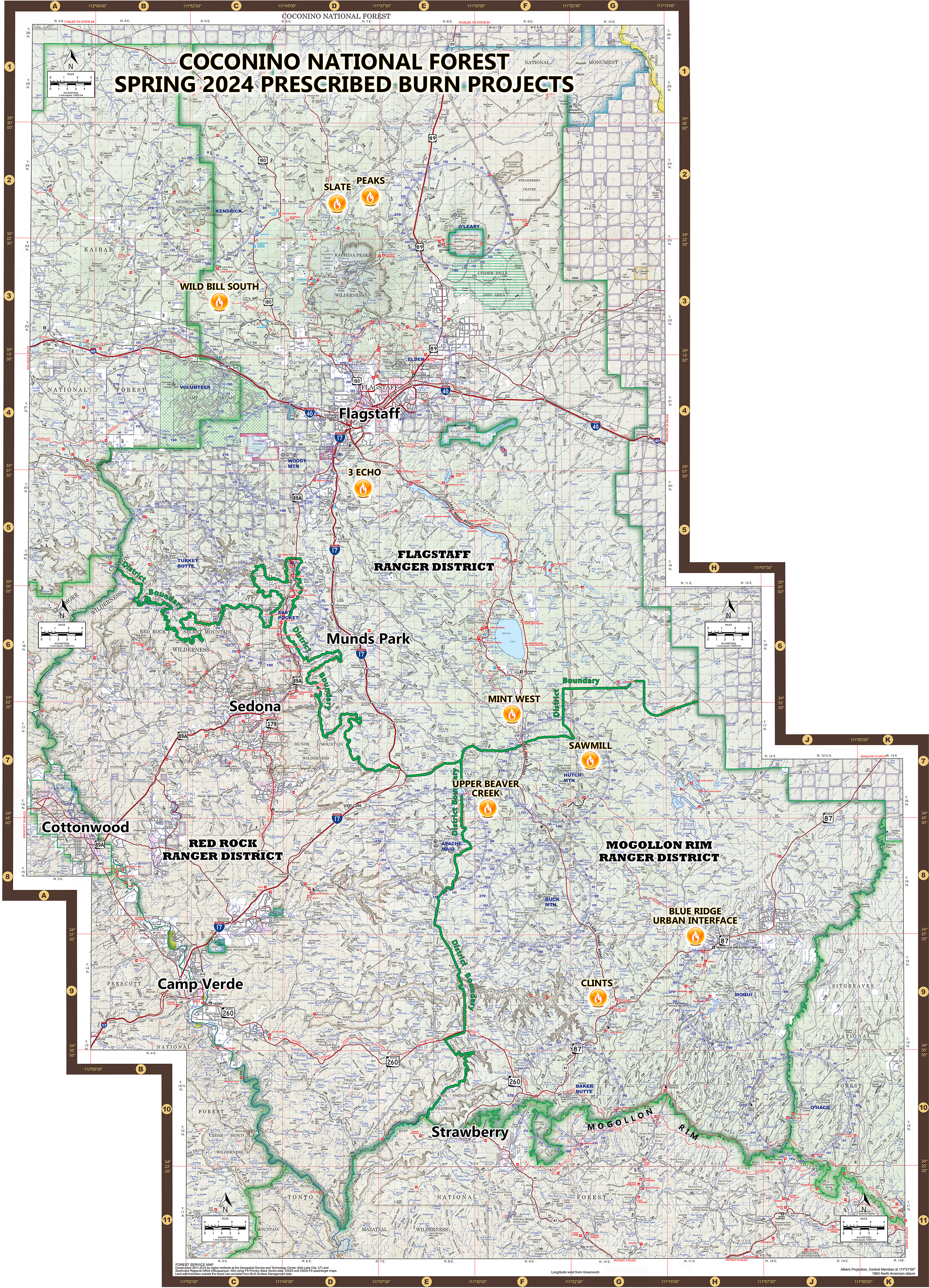
Planned prescribed fire projects on the Coconino National Forest for the spring of 2024.
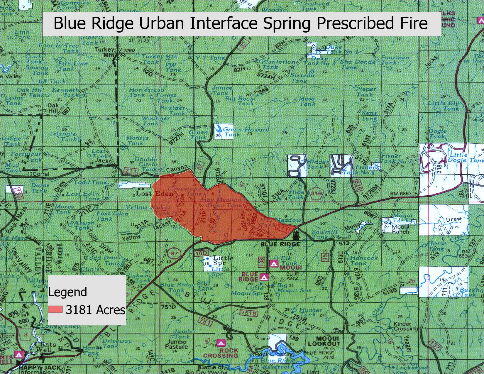
A map shows the proposed project area for the Blue Ridge Urban Interface prescribed fire.
The Mogollon Rim Ranger District of the Coconino National Forest has several prescribed fire plans slated for the spring of 2024. More details regarding prescribed fire plans will be posted closer to time of ignition.
Spring 2024 Prescribed Fire plans:
Blue Ridge Urban Interface (project map)
- Tentative dates: May 7 through May 10, 2024
- Location: 8.5 miles northeast of Clints Well: near the Mogollon Rim Ranger Station
- Size: About 1350 acres
- Type of burn: Broadcast, maintenance. Maintenance burns usually mean wildfire has recently been through the area, which tends to mean less smoke since forest fuels will not be as thick or built up over time. Broadcast burning means firefighters use tools, such as drip torches, to move fire across large swaths of land.
- Smoke impacts: Smoke may impact Highway 87 and the Blue Ridge subdivisions, as well as possible impacts to the Winslow and Holbrook areas. Due to recent land treatments, smoke impacts are expected to be light in duration.
- Why: This project will continue 20 years of routine fire treatment in the Blue Ridge area to protect nearby infrastructure and maintain landscape health.
- Notes: There are no closures anticipated. However, Arizona Trail hikers are advised to avoid the project area.
Upper Beaver Creek
- Tentative dates: Spring 2024
- Location: Roughly 4.5 miles northwest of Happy Jack: southwest of Stoneman Lake.
- Size: To be determined
- Type of burn: Broadcast, maintenance.
- Smoke impacts: To be determined
- Why: This project will reintroduce fire into a fire-adapted ecosystem.
- Notes: There are no closures anticipated.
Sawmill
- Tentative dates: Spring 2024
- Location: Roughly 4.5 miles north of Happy Jack: west of Lake Mary Road.
- Size: To be determined
- Type of burn: Broadcast, maintenance.
- Smoke impacts: To be determined
- Why: This project will reintroduce fire into a fire-adapted ecosystem.
- Notes: There are no closures anticipated.
Clints
- Tentative dates: Spring 2024
- Location: Half a mile west of Clints Well.
- Size: To be determined
- Type of burn: Broadcast, maintenance.
- Smoke impacts: To be determined
- Why: This project will reintroduce fire into a fire-adapted ecosystem.
- Notes: There are no closures anticipated.
| Current as of | Wed, 05/01/2024 - 15:06 |
|---|---|
| Incident Type | Prescribed Fire |
| Incident Commander | Coconino National Forest Mogollon Rim Ranger District |
| Incident Description | Prescribed fire projects usually commence during the early spring months in northern Arizona. If you want to sign up to receive news releases about prescribed fire and other projects on Coconino National Forest, please visit https://www.fs.usda.gov/news/coconino/news-events and click on the blue "Sign Up!" icon in the right column. Prescribed fire is important part of forest restoration projects planned in accordance with the Forest Service’s 10-year Wildfire Crisis Strategy. Prescribed fire and mechanical thinning work together to remove fuels such as woody debris and logging scraps from the forest floor during times of opportune weather. Fire managers make every effort to effectively plan and execute burn plans at times when weather allows for smoke impacts to be minimized and transport up and over communities. For more information about prescribed burns and why wildfire is a necessary part of this ecosystem, please visit our website at coconinonationalforest.us. |
| Coordinates |
34° 36' 39.6606'' Latitude
-111° 11' 29.1624
'' Longitude
|