
Highlighted Media
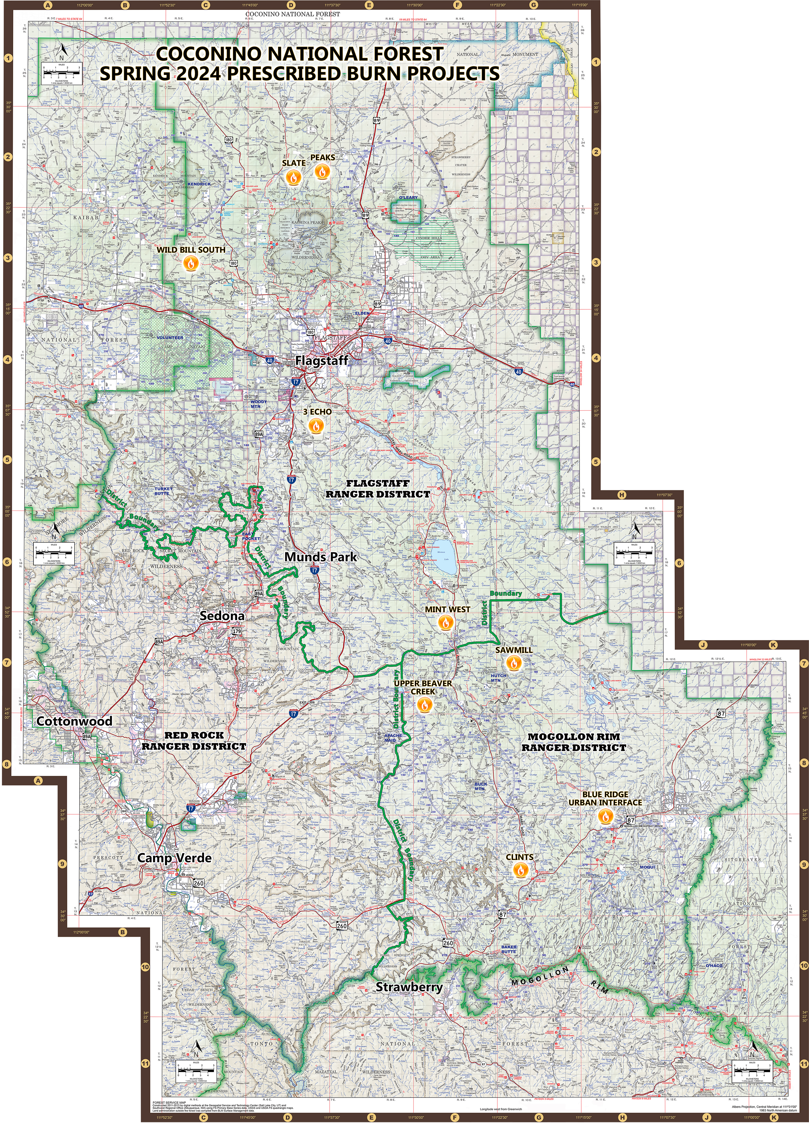
Planned prescribed fire projects on the Coconino National Forest for the spring of 2024.
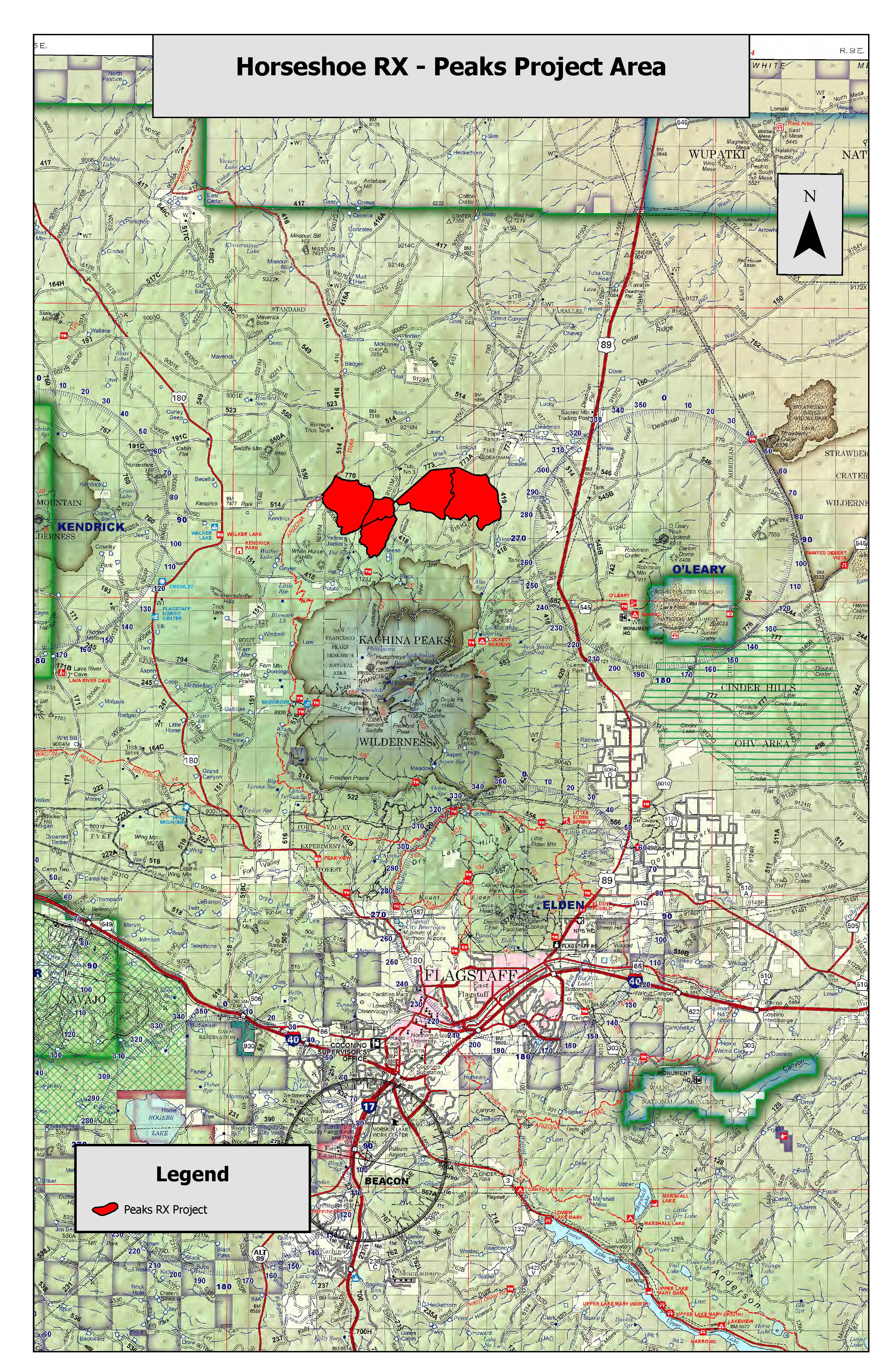
Fire managers aim to treat a portion of land located norther of the San Francisco Peaks as part of the spring 2024 Horseshoe prescribed fire project.
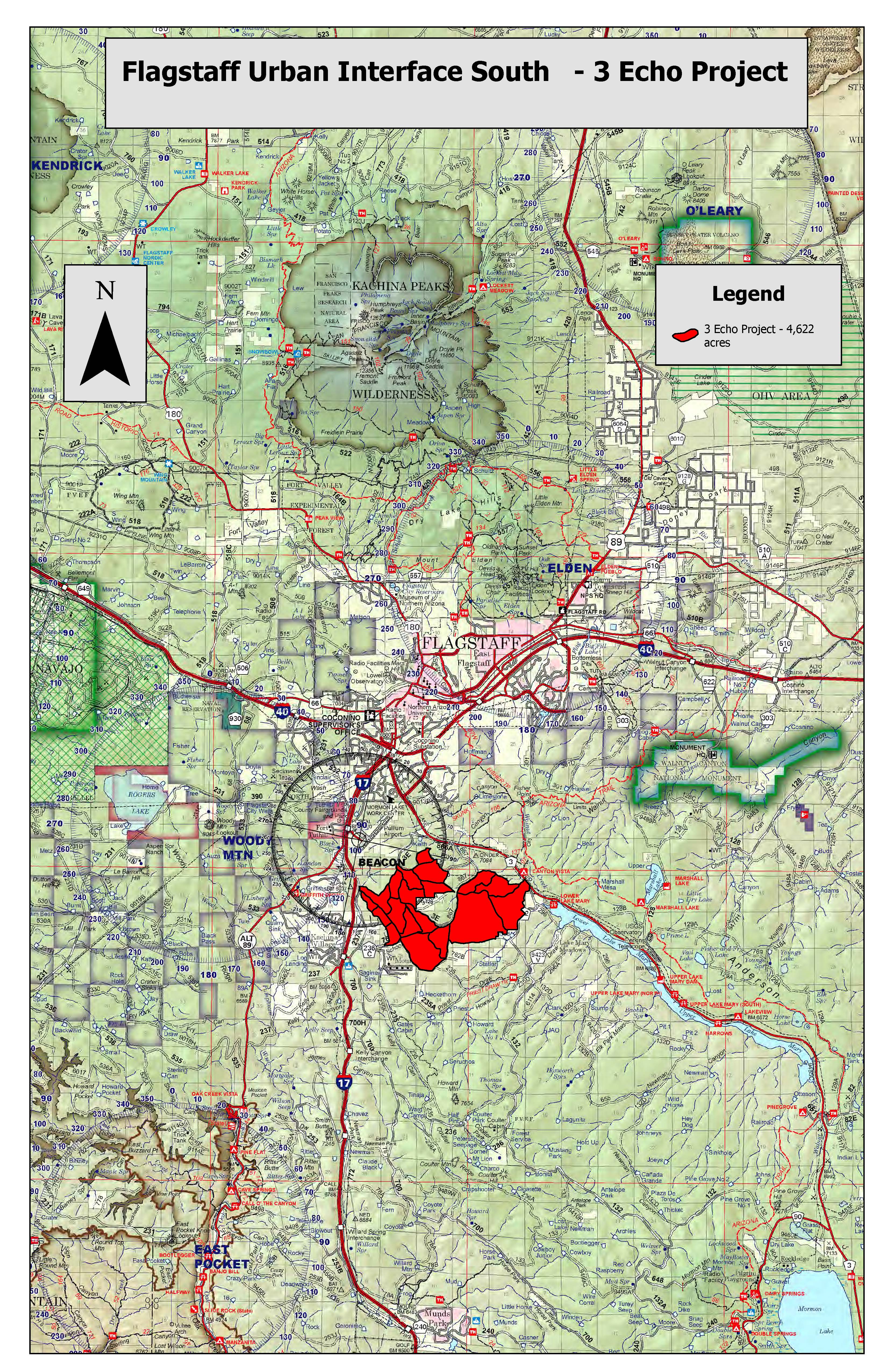
The 3Echo (3E) project is a prescribed fire planned in the Flagstaff Urban Interface (FUI). The FUI is a Wildland-Urban Interface (WUI): A zone of transition between unoccupied wilderness, and human-developed land. Should an unplanned catastrophic wildfire start in the wildland area of the WUI, critical infrastructure (such as homes, businesses and outbuildings) located in the WUI is at risk of severe damage or complete loss. By conducting land treatments such as prescribed fire, fire managers can remove unburned fuels (such as dry pine needles, dead and down trees and decomposing plant matter) to reduce the threat of wildfire damage to important infrastructure.
The 3E project will protect homes in Kachina Village and Mountainaire, as well as values at risk such as the Lake Mary watershed and nearby animal habitat.
The Flagstaff Ranger District of the Coconino National Forest has several prescribed fire plans slated for the spring of 2024.
Plans are subject to change at any time due to wind and weather conditions.
Horseshoe (Peaks project area) (project map)
- Tentative dates: May 6 and May 7, 2024 (Monday and Tuesday)
- Location: 15 miles north of Flagstaff: north of the San Francisco Peaks and west of Highway 89.
- Size: 3,963 acres.
- Type of burn: Broadcast, maintenance. Maintenance burns usually mean wildfire has recently been through the area, which tends to mean less smoke since forest fuels will not be as thick or built up over time. Broadcast burning means firefighters use tools, such as drip torches, to move fire across large swaths of land.
- Smoke impacts: Smoke is expected to travel to the northeast during ignitions. Possible impacts will be felt along Highway 89. Smoke may settle in low-lying areas overnight.
- Why: This prescribed fire will reduce fuel loading south of Flagstaff, thus lessening the risk of catastrophic unplanned wildfire during times of critical fire weather. This project also reintroduces fire into a fire-adapted ecosystem.
- Notes: There are no closures anticipated. A helicopter may be used during this project to assist with aerial ignitions.
3 Echo/ Flagstaff Urban Interface South (project map)
- Tentative dates: May 8 through May 10 (Wednesday through Friday)
- Location: 5 miles south of Flagstaff: between Lower Lake Mary and Mountainaire.
- Size: 4,622 acres.
- Type of burn: Broadcast, maintenance.
- Smoke impacts: Smoke will be highly visible from the City of Flagstaff and all surrounding areas. Smoke is expected to travel in an east or northeast direction during ignitions, and possible daytime impacts will be felt on the east side of Flagstaff, along Interstate 40, at Walnut Canyon National Monument, along Lake Mary Road south of Flagstaff and in the Continental community. Smoke may settle in low-lying areas overnight.
- Why: This prescribed fire will reduce fuel loading south of Flagstaff, thus lessening the risk of catastrophic unplanned wildfire during times of critical fire weather. This project also reintroduces fire into a fire-adapted ecosystem.
- Notes: There are no closures anticipated.
Horseshoe (Wild Bill project area) (project map)
- Tentative dates: May 11 and May 12 (Saturday and Sunday)
- Location: 14 miles northwest of Flagstaff: 4.5 miles north of Bellemont
- Size: 3,960 acres
- Type of burn: Broadcast, initial entry. Initial entry burns mean wildfire has not been through the area in a very long time and thus results in thicker smoke due to a large amount of forest fuels being present that must be burned.
- Smoke impacts: Possible smoke impacts will be felt along Highway 180 and in and around Kendrick Park during the daytime. Possible smoke impacts may be felt in the Bellemont area and along Interstate 40 overnight.
- Why: This prescribed fire will reduce fuel loading in the project area. Additionally, it will provide protection to the Upper Rio de Flag watershed, which will reduce the ensuing risk of catastrophic wildfire and subsequent flood damage to the City of Flagstaff.
- Notes: There are no closures anticipated.
Mint West
- More information about this project will be posted here when closer to implementation.
| Current as of | Wed, 05/01/2024 - 15:08 |
|---|---|
| Incident Type | Prescribed Fire |
| Incident Commander | Coconino National Forest Flagstaff Ranger District |
| Incident Description | Prescribed fire projects usually commence during the early spring months in northern Arizona. If you want to sign up to receive news releases about prescribed fire and other projects on Coconino National Forest, please visit https://www.fs.usda.gov/news/coconino/news-events and click on the blue "Sign Up!" icon in the right column. Prescribed fire is important part of forest restoration projects planned in accordance with the Forest Service’s 10-year Wildfire Crisis Strategy. Prescribed fire and mechanical thinning work together to remove fuels such as woody debris and logging scraps from the forest floor during times of opportune weather. Fire managers make every effort to effectively plan and execute burn plans at times when weather allows for smoke impacts to be minimized and transport up and over communities. For more information about prescribed burns and why wildfire is a necessary part of this ecosystem, please visit our website at coconinonationalforest.us. |
| Coordinates |
35° 13' 43.6044'' Latitude
-111° 34' 49
'' Longitude
|