
Single Publication
Could not determine your location.
 Wildfire
 Prescribed Fire
 Burned Area
Response
Burned Area
Response Other
Other
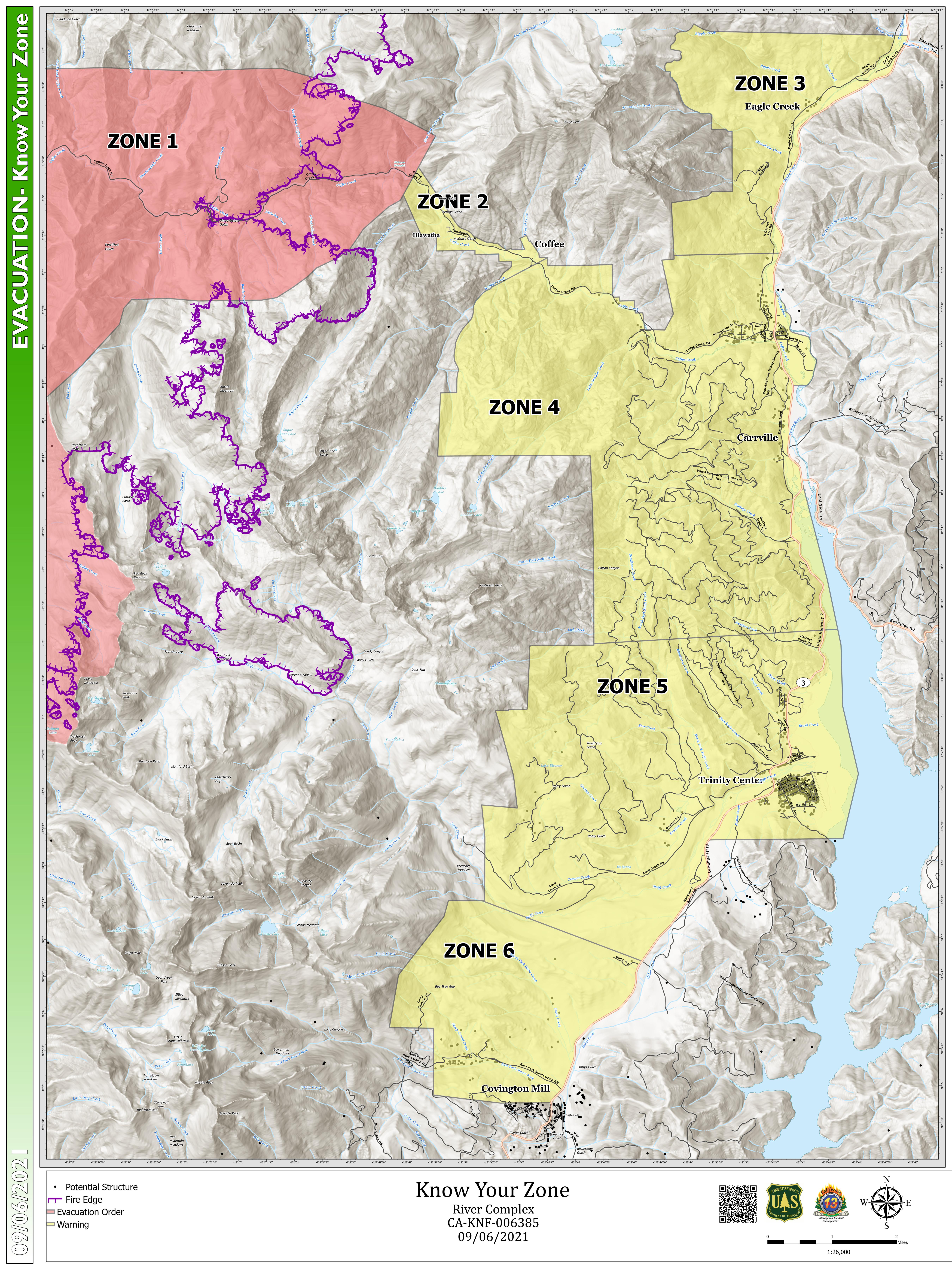
COFFEE CREEK AND TRINITY CENTER EVACUATION ZONE DESCRIPTIONS
River Complex 2021
Publication Type: News 09/06/2021
ZONE 1 – The areas along Coffee Creek Road, starting just West of the intersection of the East Fork of Coffee Creek continuing to Big Flat Trail Head. This area includes all Coffee Creek Road addresses greater than 6000. Sections along Coffee Creek Road include (going from East to West) 30, 25, 26, 27, 28, 34, 33, 29, 20, 30, 31, 6, 7, 18, 19, 21.
ZONE 2 – The areas along Coffee Creek Road, starting West of the Gold Field Campground, to the East Fork of Coffee Creek. This area includes Boulder Creek Road, FS Road 37N19Y, Gold Fish Campground, and McGuire Gulch. This area includes all Coffee Creek Road addresses between 4950 & 6000 and all properties adjacent along Coffee Creek Road. Sections from East to West included are 4, 33, 5, 32, 30. Other Sections adjacent to these should be included.
ZONE 3 – State Route 3 north from the Trinity River CG to Ramshorn Road. West of Ramshorn Road to the Trinity Alps Wilderness, south to Billys Peak. Billys Peak east to North Derrick Flat Road. This area includes Billys Peak Road, and Eagle Creek Loop Road, and Ripple Creek Cabins. Sections going from South to North include but are not limited to: 31, 32, 29, 30, 20, 21 and the southern portions of Sections 15, 16
ZONE 4 – Billys Peak southeast to State Route 3/ North Derrick Flat Road area. State Route 3 South through Coffee Creek Proper to Hatchet Creek Road. Hatchet Creek Road west to the Wilderness boundary. The wilderness boundary north to Coffee Creek Ranch. This area includes all remaining areas of Coffee Creek not included in Zones 1 or 2 and Carrville.
ZONE 5 – State Route 3 at Hatchet Creek Road south through Trinity Center proper to Hobel Dump Road. Hobel Dump Road west to Swift Creek and north to the east side of Ycatapom Peak. This area includes all of Trinity Center and the west shore of Trinity Lake north of the Trinity Center Boat Ramp, Rancheria Creek, North Fork Swift Creek, The Knolls, Trinity Meadows, the KOA, North Fork Cutoff and Gratten Flat.
ZONE 6 – State Route 3 at Hobel Dump Road south to Long Canyon Road. State Route 3 at Long Canyon Road west to the Long Canyon Trail Head. Long Canyon Trail Head north to Swift Creek, north east portions of Lake Forest Estates, including Lake Forest Drive. All Long Canyon residences and addresses, including Mountain Aire addresses and residences.