
Single Publication
Settings - change map background and toggle additional layers
Filter - control incident types displayed on map.
Zoom to your location
Reset map zoom and position
Could not determine your location.
Show Legend
 Wildfire
 Prescribed Fire
 Burned Area
Response
Burned Area
Response Other
Other
Hermits Peak and Calf Canyon Fire Daily Update for June 10, 2022
Calf Canyon
Publication Type: News 06/10/2022
Hermits Peak and Calf Canyon Fires
June 10, 2022, Daily Update, 08:00 AM
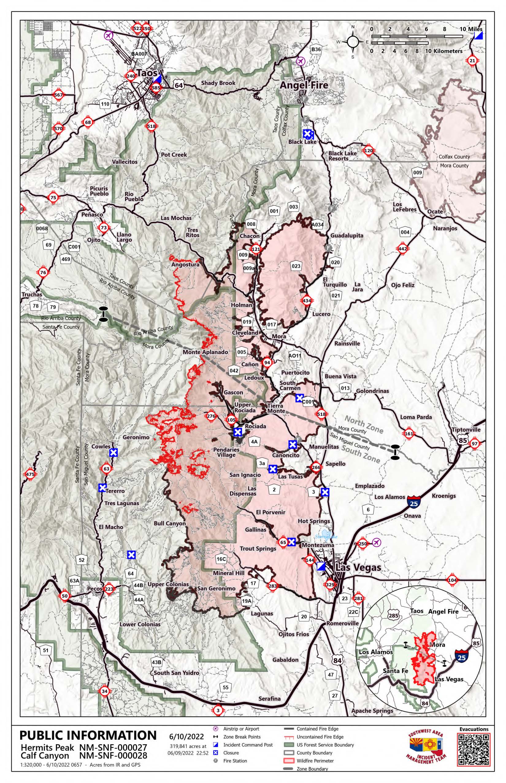
Acres: 319,841 | Containment: 67% | Total personnel: 2,685 |
Start Date: Hermits Peak: April 6, 2022; Calf Canyon: April 19, 2022 | Cause: Hermits Peak: Spot fires from prescribed burn; Calf Canyon: Holdover fire from prescribed pile burn | Location: Located near Gallinas Canyon | Fuels: Heavy mixed conifer, ponderosa pine, brush, and grass
Highlights: Areas in "Set" evacuation status are open to residents only. Firefighters and heavy equipment are still working in these areas, and additional traffic from non-residents poses a hazard to fire personnel and the public. Please fill out the Private Property Suppression Repair Survey (https://tinyurl.com/suppressionrepair) if your property sustained damage from suppression activities. This information will assist fire officials and counties in evaluating properties and contacting owners.
South Zone (SWIMT2): Scattered showers over the fire yesterday helped minimize fire movement. However, the fire will become more active over the next few days as winds increase, temperatures rise and humidity drops. Yesterday the fire was most active in the Trampas Fire (2022) burn scar moving into Mora Flats. Water drops were made by helicopters early in the day, but afternoon storms grounded air operations. Air resources will continue with water drops to cool and slow the fire's edge as weather allows. Control lines are in place, and hoses are laid along the line and primed with water should they be needed. A wildland fire module specializing in wilderness firefighting remains at Beatty's Cabin to monitor the fire and act if necessary. Around Upper and Lower Colonias and Barillas Peak, crews are chipping and spreading slash and evaluating other suppression repair needs. Crews remain in the Mineral Hills area doing repair work and are finishing up repair activities on the east perimeter.
Closures and Restrictions: All National Forests in New Mexico have closures or restrictions in place due to extreme fire danger. To learn more about these closures and restrictions, visit: https://tinyurl.com/bdy5y99r. Information related to fire restrictions across public and private land can be found at: https://nmfireinfo.com/fire-restrictions/.
Email: 2022.hermitspeak@firenet.gov
Online: https://www.facebook.com/CalfCanyonHermitsPeak| nmfireinfo.com |tinyurl.com/HermitsYouTube | Santa Fe NF |