
Single Publication
Could not determine your location.
 Wildfire
 Prescribed Fire
 Burned Area
Response
Burned Area
Response Other
Other
Boulder Mountain Fire Daily Update September 9, 2022
Boulder Mountain Fire
Publication Type: News 09/09/2022
Friday, September 9, 2022
Boulder Mountain Fire Information 509-508-3389 (8am-8pm) | 2022.bouldermountain@firenet.gov
Quick Facts
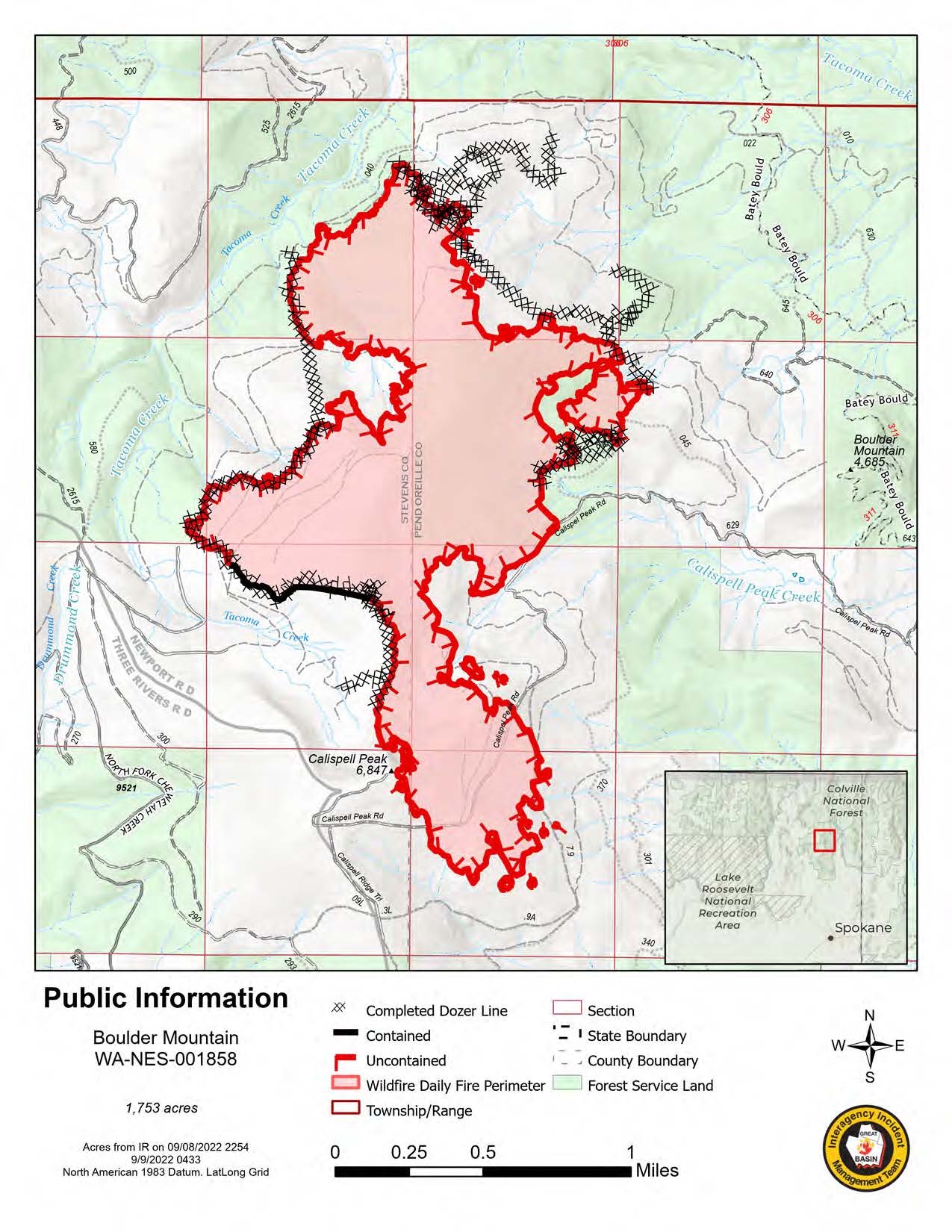
Fire Location: 9 miles NW of Cusick, WA in Tacoma Creek and Boulder Mtn.
Size: 1,753 acres
Containment: 4% (down 2%)
Start Date: 8/31/22
Cause: Under Investigation
Incident Commander: Mike Johnston, Great Basin Type 2 Incident Management Team #7
Personnel: 470
Online Links
InciWeb:
inciweb.nwcg.gov/incident/8382/
Facebook:
Washington State Department of Natural Resources:
Colville National Forest
Summary: The Boulder Mountain Fire was detected on Wednesday August 31st, 2022, at approximately 8:30 pm. The fire is located in the Tacoma Creek and Boulder Mountain area, 9 miles Northwest of Cusick, Washington. A mix of State, Federal and Private land is impacted. The terrain is difficult, and the fire is burning in heavy timber, slash, and beetle infested trees. Cause of the fire remains under investigation.
Weather|Anticipated Fire Behavior: Winds overnight remained steady from the north and northwest. The relative humidity will increase for today with steady winds continuing. Another wind shift is expected with winds from the northeast to east today. Smoky conditions in the area are likely again with transport winds bringing smoke from other fires in northern Idaho.
Actions: The increase in acreage on the south of the fire was a result of the anticipated north and northwest wind. Responders worked via ground and air to hold the fire inside the dozer line and forest road 629. The fire spread to areas in and around Calispell peak. The north and east perimeter lines saw activity within the fires perimeter as previously unburned fuels were consumed.
Resources in the northern parts of the fire will continue to strengthen hand and dozer line by mopping up, aided by hose lays along the edge. Where there was new growth yesterday resources will be assessing where the new perimeter is and how to best contain it moving forward.
Since the initial stages of The Boulder Mountain Fire, numerous plans have been developed. Often the tactics on the ground are a combination of many plans put together. Though the majority of plans involve direct and indirect attack, they also include contingency plans that could include various road systems and large geographic features that may be capable of holding the fire should it grow. This style of planning allows for quick adaptation in response to changing factors, be it wind, fire behavior, or staffing.
Important Information: Over the last few days most resources have been moved to “spike camps” or small, remote camps closer to the fire that are supported by the main incident command post, located at the Kalispel Pow Wow Grounds. This mean that there will be less traffic on the surrounding roadways but please be sure there are still hundreds of firefighters working hard to contain the Bolder Mountain fire.
Though the overall containment percentage did decrease by 2%, it is important to note, that is due to the increase in perimeter size and the area that was contained remains in place.