
Single Publication
Could not determine your location.
 Wildfire
 Prescribed Fire
 Burned Area
Response
Burned Area
Response Other
Other
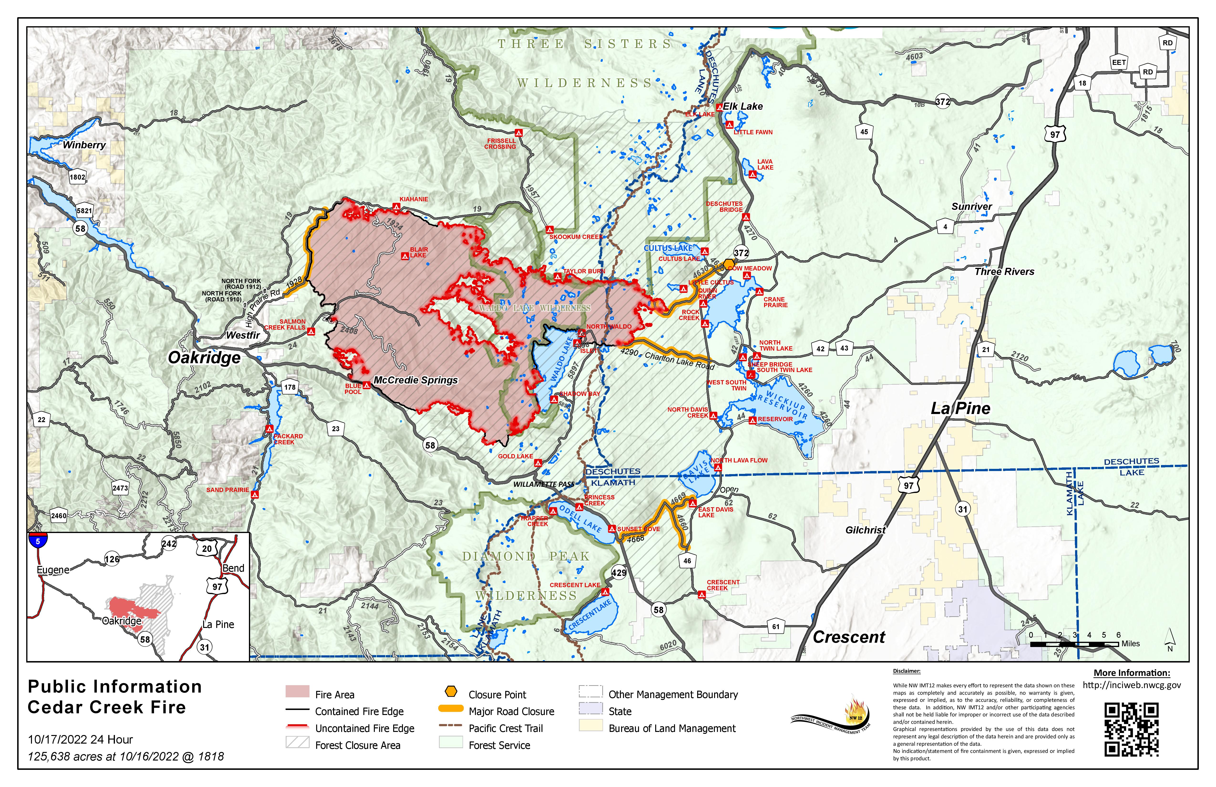
Cedar Creek Fire Update October 17, 2022
Cedar Creek Fire
Publication Type: News 10/18/2022
October 17, 2022 | Size: 125,638 acres | Origin: 15 miles E of Oakridge, OR | Containment: 45% | Cause: Lightning | Total personnel: 663 | Resources: 19 engines; 12 crews; 7 helicopters; 9 heavy equipment | Start Date: August 1, 2022
Weather: A shift in fire weather is expected to moderate burning conditions today. The upper-level ridge will shift inland today in response to a couple of in-coming weather disturbances. This will result in cooler temperatures with higher relative humidity. High temperatures will be 8-10 degrees cooler than yesterday with highs mainly in the upper 60s to mid-70s. Relative humidity will be 5-10 percent higher and around 25-35 percent. Winds will be mainly northwest around 10 mph.
Operations: Crews will be holding and securing any areas of remaining heat in areas that saw increased activity with the critical fire weather. Repair and rehabilitation projects continue. Air resources have been heavily engaged in operations whenever it is safe to fly, providing support to firefighters on the ground.
Firefighters on the north end of the fire continue suppression repair on Forest Service Roads 750 and 1944. They are also securing the fire edge on Forest Service Roads 19 and 1938. They will continue to monitor, patrol, and mop up both direct and indirect primary lines. On the east side of the fire, crews are patrolling the 4290 road, completing suppression repair and road grading on the 640 and 4668 to return roads to pre-fire conditions. Chipping operations near Cultus Lake have been completed. To the south, crews are patrolling the 5883 road. They will continue to hold and secure control lines on spot fires. Crews on the western edge of the fire are also patrolling and securing Forest Service Roads including 352 and 353 and securing control line along 5871.
Suppression repairs on the Big Swamp and Potter Fires were completed yesterday.
Closures: There are closures in effect on the Deschutes National Forest and Willamette National Forest. These closures will remain in place until areas impacted by the fire are surveyed for safety risks and fire crews are able to mitigate these hazards. Please respect Forest closures for firefighter and public safety. Please visit Willamette National Forest and Deschutes National Forest for the most recent closure orders and maps. Pacific Crest Trail hikers should visit pcta.org for current information. There is a Temporary Flight Restriction over the Cedar Creek Fire area. Wildfires are a No Drone Zone - if you fly, we can’t.
Smoke: Air quality conditions due to smoke are expected to be Good to Hazardous within the forecast area. Smoke impacts will be heavily dependent on fire activity. For current conditions, see Fire.airnow.gov, oakridgeair.org, and LRAPA - Today's Current Air Quality. Smoke Forecast Outlooks are available at https://outlooks.wildlandfiresmoke.net/outlook.
Evacuations: A map of the evacuation area is available at www.LaneCountyOR.gov/CedarCreek. Sign-up for emergency mobile alerts by going to oralert.gov. Please check with Lane County Sheriff’s Office at 541-682-4150 and Deschutes County Sheriff’s Office at 541-693-6911 for updates and changes.
Online: https://inciweb.nwcg.gov/incident/8307/ | www.facebook.com/CedarCreekFire2022/ www.tinyurl.com/cedarcreekfireyoutube| Fire Information Line: 541-201-2335, 8:00 AM – 8:00 PM | For Media Inquiries: 541-327-9925 | Email: 2022.cedarcreek@firenet.gov