
Single Publication
Could not determine your location.
 Wildfire
 Prescribed Fire
 Burned Area
Response
Burned Area
Response Other
Other
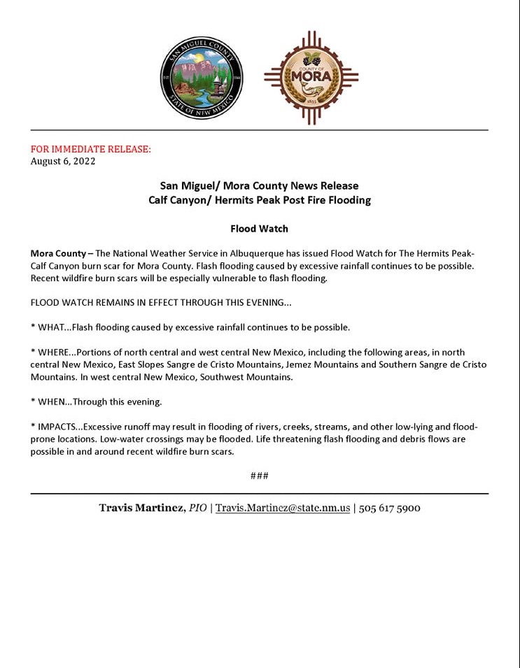
Flash Flood Warning 08/06/2022 until 1615 This Afternoon
Hermits Peak Fire
Publication Type: Announcement 10/26/2022
The National Weather Service in Albuquerque has issued a
Flash Flood Warning for The Hermits Peak Calf Canyon Burn Scar
Southeastern Rio Arriba County in north central New Mexico
Northeastern Santa Fe County in north central New Mexico
Southeastern Taos County in north central New Mexico
Southwestern Colfax County in northeastern New Mexico
Western Mora County in northeastern New Mexico
Northwestern San Miguel County in northeastern New Mexico
Until 415 PM MDT.
At 1216 PM MDT, Doppler radar indicated thunderstorms producing heavy rain over the Hermits Peak Calf Canyon Burn Scar. Additional rainfall amounts of 0.5 to 1.5 inches are possible in the warned area. Flash flooding is ongoing or expected to begin shortly.
Excessive rainfall over the burn scar will impact Manuelitas Creek, Sapello River, Rio San Jose, Santiago Creek, Rito Cebolla, Rio La Casa, Vigil Creek, Coyote Creek, Mora River, and La Canada del Carro. The debris flow can consist of rock, mud, vegetation and other loose materials.
HAZARD Life threatening flash flooding. Thunderstorms producing flash flooding in and around the Hermits Peak Calf Canyon Burn Scar.
SOURCE: Radar.
IMPACT: Life threatening flash flooding of areas in and around the Hermits Peak Calf Canyon Burn Scar.
Some locations that will experience flash flooding include: Mora, Morphy Lake State Park, Cleveland, Ledoux, Gascon, Holman, Tierra Monte, La Cueva, Chacon, Cowles, Coyote Creek State Park, Black Lake, Monte Aplanado, South Carmen, Rociada, San Ignacio in Guadalupe County, Luceros, El Turquillo, Manuelitas and Rainsville.
This includes the following highways;
State Road 94 between Mile Markers 1 and 18.
State Road 266 between Mile Markers 0 and 6.
State Road 105 between Mile Markers 0 and 9.
State Road 276 between Mile Markers 0 and 5.
State Road 518 between Mile Markers 14 and 47.
State Road 434 between Mile Markers 0 and 29.
State Road 283 near Mile Marker 13.
State Road 65 near Mile Marker 14.
State Road 63 between Mile Markers 21 and 25.
State Road 121 between Mile Markers 0 and 8.
FLASH FLOOD RADAR INDICATED
FLASH FLOOD DAMAGE THREAT: CONSIDERABLE
Instructions: Runoff from rainfall will cause elevated water levels within vulnerable drainages in and downstream of the HPCC fire burn area. Do not camp along streams and rivers. Remain alert when hiking in steep, narrow canyons. Know where you are relative to low spots and drainages.
Target Area:
Colfax
Mora
Rio Arriba
San Miguel
Santa Fe
Taos