
Single Publication
Could not determine your location.
 Wildfire
 Prescribed Fire
 Burned Area
Response
Burned Area
Response Other
Other
Ross Fork Fire Daily Update, Wednesday, September 14
Ross Fork
Publication Type: News 09/14/2022
Ross Fork Fire Daily Update
September 14, 2022
Fire Information: Email: 2022.rossfork@firenet.gov Phone:208-329-6044 daily from 8 a.m. - 8 p.m.
Sawtooth National Forest Facebook: https://www.facebook.com/sawtoothnationalforest
YouTube: https://youtu.be/Ll7iJz55hnI Inciweb: https://inciweb.nwcg.gov/incident/8375
Containment: 19%
Cause: Lightning
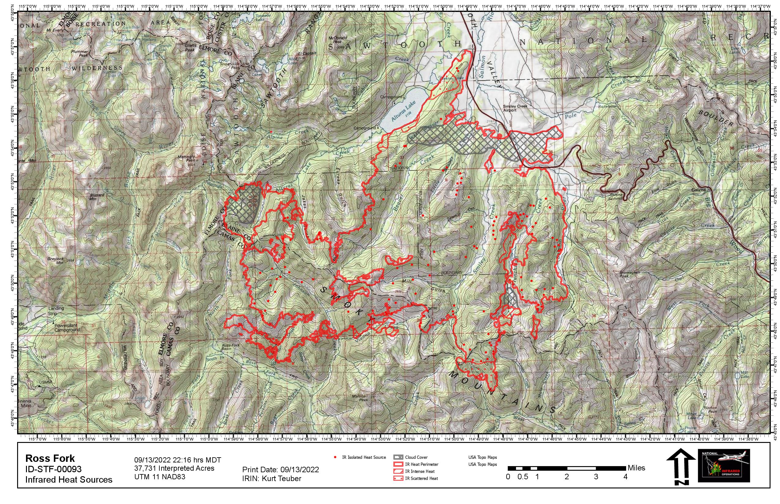
Acreage: 37,731 Acres
Location: Sawtooth National Forest, Idaho
Fuel Typ: Timber Litter/Timber/Short Grass
A community meeting will be held in Fairfield tonight, Wednesday, September 14th at 6 p.m., at the Camas County Senior Center, 129 Willow Avenue West. Fire personnel will give an update on fire activity and answer questions. The event will be recorded and shared on the fire’s YouTube channel and the Sawtooth NF Facebook page. If possible, the event will be livestreamed on Facebook.
Up to 3/10” of rain fell across the fire area intermittingly beginning Monday night and through Tuesday. A cool, moist pattern will continue for the rest of the week, moderating fire behavior. The Fire Behavior Analyst (FBAN) on the Ross Fork Fire says the moisture will prevent grasses and shrubs from burning unless there is an extended drying trend. There are still many areas of intense heat within the fire perimeter. This means heavier fuels, such as large logs and even live trees, will continue to burn until larger amounts of rain or snow fall. The Incident Meteorologist says that while the rain is a significant help, it is not yet a fire “season ending” event.
Crews will take advantage of the lower fire behavior to strengthen containment lines, continue hazardous tree removal (along roads and firelines) and begin repairing three miles of bulldozer line. Firefighters have begun removing and chipping slash along the Alturas Creek Road. The mulch will be used for future projects on the forest. In addition, crews will continue mop up and repair work inside the fire perimeter to ensure safe travel through the area once it is reopened. Firefighter and public safety is always the highest priority during a wildfire, to include minimizing fire-created hazards before leaving the incident.
The USDA Forest Service and Idaho Department of Lands initiated Stage 1 fire restrictions on the Sawtooth North Zone, effective Sunday, September 11. The order encompasses lands north of Highway 20 to the northern most Sawtooth National Forest boundary situated in Blaine, Camas, and portions of Custer, Elmore, and Boise counties, can be found at: https://www.fs.usda.gov/Internet/FSE_DOCUMENTS/fseprd1059189.pdf. Stage 1 fire restrictions apply to all state, state endowment, and private land in the North Zone that lie within the boundary of the Sawtooth National Forest.
TRAFFIC AND DRIVING CONDITIONS: Highway 75 has been open continuously for the past six days but still may be subject to intermittent safety closures. Current road information is at https://511.idaho.gov/.
CLOSURES AND RESTRICTIONS: Closure order 0414-05-059 has been issued by the Sawtooth National Forest for areas surrounding the #RossForkFire on the Sawtooth National Recreation Area AND Fairfield Ranger District. Visit https://www.fs.usda.gov/alerts/sawtooth/alerts-notices, for more information.
AIR QUALITY: Wildfire smoke can be hazardous to your health. For more information, please visit: https://www.airnow.gov
EVACUATIONS: The Pettit Lake Road, Cabin Creek Road and Alturas Lake areas have been reduced to “SET” evacuation status; however, these areas are within the forest closure and are not open to the public nor homeowners. Smiley Creek and Sawtooth City remain in a “GO” status. The Galena area remains in “SET” status – trails, forest roads, and public facilities in that area are open, if they are outside the forest closure area. Visit https://www.blainesheriff.com/152/Sheriff for more information.
TOTAL FIRE RESOURCES ASSIGNED:
Personnel
702
Hand Crews
15
Engines
47
Helicopters
7
Visit our website at: www.fs.usda.gov/Sawtooth and on Facebook at: https://www.facebook.com/sawtoothnationalforest