
Single Publication
Could not determine your location.
 Wildfire
 Prescribed Fire
 Burned Area
Response
Burned Area
Response Other
Other
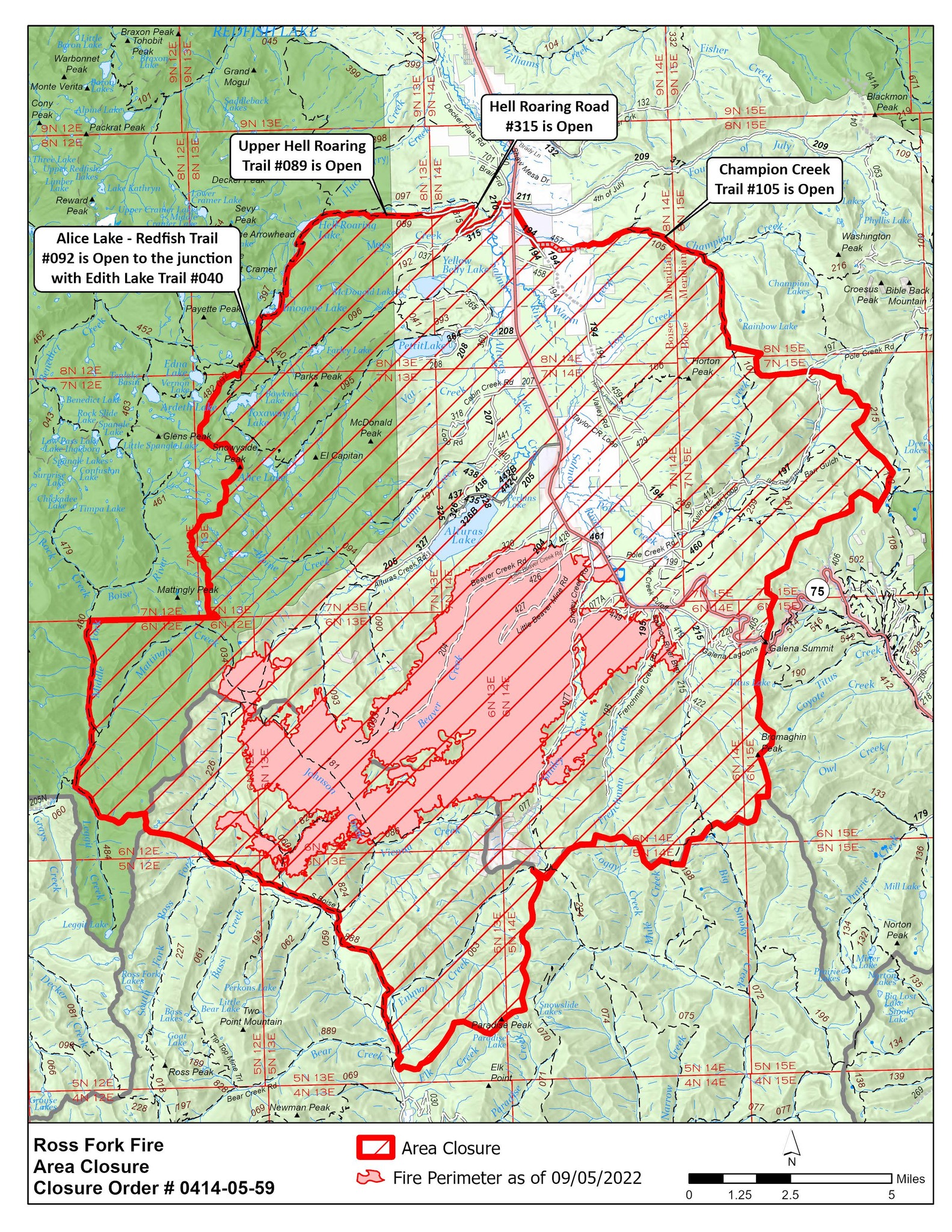
Ross Fork Fire Area Closure, Version 3, September 6
Ross Fork
Publication Type: Closures 09/07/2022
Order Number: 0414-05-057
UNITED STATES DEPARTMENT OF AGRICULTURE
FOREST SERVICE
SAWTOOTH NATIONAL FOREST FAIRFIELD RANGER DISTRICT &
SAWTOOTH NATIONAL RECREATION AREA
National Forest Area, Road, and Trail Closure (For Public Safety)
Ross Fork Fire – Version 3
PROHIBITIONS:
Pursuant to 16 U.S.C. § 551 and 36 CFR 261.50 (a) and (b), the following act is prohibited on the National Forest System (NFS) lands and trails within the Fairfield Ranger District, Sawtooth National Forest, described below and shown on the attached map incorporated into this Order in Exhibit A (“Closed Area” and “Closed Trails”):
- Going into or being upon the Closed 36 CFR 261.52(e), 261.53(e)
- Being on the Roads described below. 36 CFR 261.54(e)
- Being on the Trails described below. 36 CFR55(a)
EXEMPTIONS:
Pursuant to 36 CFR 261.50(e), the following persons are exempt from this Order:
- Persons with a special use authorization or other Forest Service authorization specifically exempting them from the effect of this Order.
- Any Federal, State, or local officer, or member of an organized rescue or fire fighting force in the performance of an official duty.
- Federal or State administrative personnel in the performance of an official
CLOSED AREA AND TRAILS DESCRIPTION:
The Closed Area is within the Fairfield Ranger District, Sawtooth National Forest, Camas County, Idaho, Boise Meridian and the Sawtooth National Recreation Area, Sawtooth National Forest, Blaine and Custer Counties, Idaho, Boise Meridian. The Closed Area is all NFS lands within the following boundaries:
- Beginning at the bridge over the South Fork of the Boise River, National Forest Road #079, Section 34, T5N, R13E, and continuing north by northwest along and including the Ross Fork Jeep Trail #888 to its intersection with the North Fork Ross Trail #226 in Section 2, T5N, R12E;
- Continuing to the north along and including the North Fork Ross Trail #226 for ½ mile in Section 35, T6N, R12E; Then following the ridgeline to the west in Sections 35 and 34 to the administrative boundary of the Fairfield Ranger District and the Sawtooth Wilderness at Rossview Peak in Section 34, T6N, R12E;
- Continuing west and following a perennial stream that drains into Leggit Creek to the Leggit Creek Trail #484 in Section 33, T6N, R12E;
- Continuing north along and including Leggit Creek Trail #484 to the intersection with Middle Fork Boise River Trail #460;
- Continuing north along and including the Middle Fork Boise River Trail #460 to the dividing line between Section 5, T6N, R12E and Section 34, T7N, R12E about ¾ miles south by southwest from the intersection of Middle Fork Boise River Trail #460 and Timpa Creek Trail #479;
- Continuing east along the dividing line between T6N, R12E at Section 5 and T7N, R12E at Section 34 to National Forest boundary in Section 31, T7N, R13E;
- Continuing north along the National Forest Boundary to the junction with Alice Lake-Redfish Trail #092 in Section 32 T8N, R13E;
- Continuing north northeast along Alice Lake-Redfish Trail #092 to the junction with Upper Hellroaring Trail #089 in Section 14, T8N, R13E;
- Continuing west along the Upper Hellroaring trail 089 to the junction with Hellroaring Road #315 in Section 18, T8N, R14E;
- Continuing west along Hellroaring road 315 to the junction with State Highway 75 where Sections 8, 9, 16 and 17 join in T8N, R14E;
- Continuing due south on State Highway 75 about ½ mile to the junction with Champion Creek in Section 16, T8N, R14E;
- Continuing south and east along Champion Creek to where the creek intersects Trail 107 in Section 19, T8N, R15E;
- Continuing south along Trail 107 to the headwaters of the South Fork of Champion Creek approximately 2 miles at Section 5, T7N, R15E;
- Continuing due east approx. ½ mile to the boundary between Big Game Management Units 36 and 36A;
- Continuing following the Big Game Unit Boundary south across State Highway 75 near the Galena Summit in Section 7, T6N, R15E to the Sawtooth National Recreation Area boundary in Section 30, T6N, R15E;
- Continuing west along the Sawtooth National Recreation Area boundary to the junction with the Emma Creek Trail #063 in Section 6, T5N, R14E;
- Continuing south along the watershed divide of Emma Creek and the West Fork of Big Smoky Creek to Paradise Peak, Section 25, T5N, R13E;
- Continuing westerly along the watershed divide of Emma Creek and Elk Creek to South Fork of the Boise River in Section 34, T5N, R13E;
- Continuing north along the South Fork Boise River to the point of origination on Forest Road #079 at the bridge of the South Fork of the Boise River in Section 34, T5N, R13E.
The Closed Trails are all NFS Trails or portions of NFS Trails within or bordering the Closed Area: #033, #034, #040, #041, #060, #063, #072, #086, #090, #092, #093, #094, #095, #096, #097, #106, #107, #112, #117, #181, #191, #192, #198, #224, #226, #227, #256, #257, #258, #259, #261, #264, #265, #393, #397, #403, #404, #460, #484, #514, #824, #825, #888.
The Closed Roads are all NFS Roads or portions of NFS Roads within or bordering the Closed Area: #037, #077, #194, #195, #197, #199, #204, #205, #207, #208, #209, #210, #215, #220, #316, #318, #320, #324, #325, #326, #327, #328, #329, #360, #361, #362, #363, #364, #365, #367, #402, #405, #410, #412, #414, #417, #419, #422, #426, #427, #428, #429, #430, #435, #436, #437, #438, #439, #440, #441, #442, #443, #445, #446, #449, #458, #459, #460, #461, #077A, #205A, #205B, #207A, #326A, #326B, #440A, #440B, #442A, #442B, #442C, #442D, #446A.
PURPOSE:
To protect public safety during active firefighting operations.
IMPLEMENTATION:
- This Order will be in effect September 6, 2022, at 10:00 M. and shall remain in effect until November 15, 2022, at 5:00 P.M.
- A map identifying the Closed Area is attached and made part of this
- A violation of the above prohibition(s) is punishable by a fine of not more than
$5,000 for an individual or $10,000 for an organization, imprisonment for not more than six months, or both. [16 U.S.C § 551, 18 U.S.C §§ 3559, 3571, 3581].
- Further information regarding this Order may be obtained at the Fairfield Ranger District (208) 764-3202 and the Sawtooth Forest Supervisor’s Office (208) 423- 7500 in Twin Falls, ID.
Done at Jerome, Idaho this 6thday of September 2022.
REBECCA HOTZE
Acting Forest Supervisor, Sawtooth National Forest