
Single Publication
Could not determine your location.
 Wildfire
 Prescribed Fire
 Burned Area
Response
Burned Area
Response Other
Other
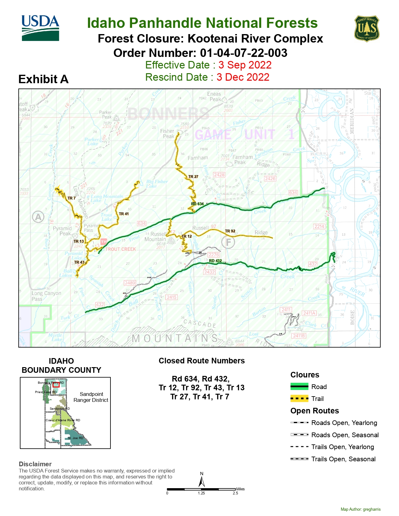
Kootenai River Complex
Incident Contacts
- IPNF Fire Information LinePhone:208-557-8813
- Kootenai River Complex Fire Information LinePhone:208-202-5021Hours:Monday - Sunday 7am to 9pm
- Bonners Ferry Ranger District - Closure InfoPhone:208-267-5561Hours:Monday - Friday 7:30 am to 4:00 pm
Kootenai River Complex Fire Fact Sheet 10/28/2022
Kootenai River Complex
Publication Type: News 10/28/2022
Kootenai River Complex Update Friday, October 28, 2022
Facebook: https://www.facebook.com/USFSIPNF
Idaho Panhandle National Forests, Bonners Ferry Ranger District
![]() Phone: (208) 557-8813
Phone: (208) 557-8813
**Additional updates will occur only if there is a change in conditions**
Location: 7 miles NW of Bonners Ferry, ID, in Boundary County, ID Size: 25,402 acres
Personnel: 9 Completion: 100% Incident Commander: ICT4 Ohweiler
Highlights: There is minimal fire activity with some flanking, backing, and creeping. The fire is a mix of timber fuels including subalpine fir, lodgepole, larch, cedar, and mixed shrub understory with huckleberry. Heavy dead and down logs combined with standing dead trees along with steep topography pose a hazard to firefighters.
This time of year, fire activity is significantly reduced due to precipitation, shorter days, lower temperatures, and higher daytime humidity[MKF1] [BJFNI2] [BJFNI3] . Expect to see continued smoke until the snow falls or significant rain occurs. Still, with decreased fire behavior, the threat is much less than it was earlier in the season. In areas around properties where the threat is significantly reduced, like those with cold burned areas around them, crews are assessing where structure protection equipment like pumps and hoses can be taken down.
Firefighters plan to conduct suppression repair actions where appropriate in the areas around Trout Road and Ball Creek Road. Using heavy equipment and hand tools firefighters work to take measures to repair damage to areas where firefighting action has occurred as well as remove some lingering dangers left by the fire. During this time firefighters will continue to remove handlines, hoses, and sprinkler systems, and work to remove snags while reassessing the area dangers and safety concerns as it impacts public use and travel. During this work, firefighters will create log decks and slash piles as they remove hazardous fuels and restore natural areas. THESE LOG DECKS ARE NOT FOR PUBLIC CONSUMPTION. When venturing out please note that taking from these piles is PROHIBITED.
Closures & Evacuations: Where possible, closures have been reduced. Effective 10/28/2022, the following roads and trails are now open:
McGinty Ridge Trail (No. 143) and Clifty Trail (No. 182) and Cascade Creek Road (FS 2411) and Fisher Peak Trail (No. 7)
The following National Forest Trails and Roads remain closed while firefighters reassess the safety concerns for public use:
The entirety of Ball Creek Road (FSR 432), Trout Creek Road (FSR 634), and Burton Road (FSR 2411). Also, the Parker Ridge Trail (No. 221), Russell Mountain Trail (No. 12), Russell Ridge Trail (No. 92), Ball & Pyramid Lakes Trail (No. 43), Pyramid Pass Trail (No. 13), Pyramid Peak Trail (No. 7), Fisher Peak Trail (No. 27), Myrtle Peak Trail (No. 286), Burton Peak Trail (No. 9), Trout Lake Trail (No. 41), and Long Canyon Trail (No. 16).
Please note that after our post-fire BAER team analysis, multiple high-risk hazards remain such as potential rock & debris slides, down trees, and snags; the public should NOT EXPECT Trout Creek Road (FSR634) and Ball Creek Road (FSR 432) to reopen until next year.
Changes in closure status will be promptly shared. There are NO evacuations. However, when living in fire-prone areas, it is recommended that all area residents have an evacuation plan in place, including having all important documents, pictures, prescriptions, and pets gathered up and quickly transportable. Residents of Boundary County, ID can visit https://www.nixle.com or text their home zip code to 888777 to sign up for emergency alerts.
Weather: Widespread wetting precipitation is expected to persist over most of the area. Several systems are expected throughout the week, resulting in a prolonged wet and cool period.
Hunting in the IPNF: The Idaho Panhandle National Forests encourages visitors to enjoy their public land by following travel management guidelines to minimize erosion impacts, aid in wildlife protection, provide non-motorized recreation and hunting opportunities, and protect natural resource values. Specific closure area information for the Idaho Panhandle National Forests, including maps, are posted on the IPNF Alerts & Notices web page (https://www.fs.usdalgov/alerts/ipnf/alertsnotices) statewide information on fires and closures is provided on the Idaho Department of Fish and Game’s Fire Map web page (https://idfg.idaho.gov/ifwis/maps/realtime/fire/) Prescribed fire plans can be found at http://bit.ly/NorthIdahoRxFire. In the opened areas, the public should be prepared to meet heavy equipment and other traffic on roads; be aware that weather conditions such as precipitation and wind can rapidly change conditions on the ground, especially in fire areas. Wind can blow trees across roadways and trails, and precipitation can wash debris across roads and trails, blocking access and raising stream and river levels. Forest visitors must be prepared to stay longer than expected due to changing circumstances. Preparing for the unexpected is the best plan.
###