
Single Publication
Could not determine your location.
 Wildfire
 Prescribed Fire
 Burned Area
Response
Burned Area
Response Other
Other
KNP Complex Update – October 4, 2021
KNP Complex
Publication Type: News 10/04/2021
Southwest Area Type 1 Incident Management Team 2
Dave Bales – Incident Commander
Acres: 67,708 acres (based on infrared flight)
Containment: 11%
Start Date: September 10, 2021
Cause: Lightning
Jurisdiction: Sequoia and Kings Canyon National Park; Sequoia National Forest
Resources: 1,531 ¬personnel including: 26 crews, 61 engines, 40 water tenders, 21 dozers and 12 helicopters
Late last night winds caused a spot fire across Mineral King Rd which prompted an Evacuation Order for Crest, Sierra King, Hammond, and Oak Grove. Yesterday, firefighters continued with indirect suppression tactics to secure control lines on the northwest perimeter. Tactical firing operations are being used to create a continuous line between previously established control lines and existing or natural holding features such as roads and rock scurries. In Redwood Mountain Grove, crews worked in close coordination with natural resource specialists as they progressed with strategic firing operations in the northwest. Structure protection continues in Eshom, Hartland, Silver City and Mineral King areas.
Today, along Mineral King Rd firefighters will assess how to safely engage the spot fires that occurred last night. Resources will continue to provide structure protection for those communities under Evacuation Orders. Unmanned Aircraft Systems (UAS) will be used to help gather information along the southern perimeter. The fire continues to hold east of control lines on the western perimeter. Firefighters will continue to secure lines while maintaining a presence in the Three Rivers and Ash Mountain areas. Tactical firing operations will continue as conditions allow along the northwest flank as crews progress to the north. Firefighters in Redwood Mountain Grove are working in coordination with resource advisors to establish strategic plans for future tactical firing operations. UAS may assist firefighters with tactical firing operations as they progress north along Generals Highway. Minimal fire activity was observed near the northeast corner because the fire is burning in areas with less continuous fuels. Firefighters continue to secure and extinguish heat sources near established containment lines and within the Giant Forest Grove. Aviation resources are available to support firefighting efforts on the ground as visibility allows.
Containment decreased due to the increase in fire size. We ask the public to use caution when traveling in and around the fire area as firefighters and equipment are diligently working to protect communities and construct containment lines.
The high-pressure ridge that has held smoke over the fire over the past few days will begin to break down as a low-pressure trough approaches today. This will allow a small increase in westerly winds aloft which will start to lift smoke up and out of the area. Local winds will remain light and terrain driven. Humidity levels will rise slowly as moister air moves into the area, which will help moderate fire behavior slightly in the coming days.
Evacuation Orders and Warnings remain in effect. For all detailed KNP Complex evacuation information please visit: https://nifc.maps.arcgis.com/apps/webappviewer/index.html?id=4b2ac27b5c8943ed92c0e77aa94daca0
Information about how to prepare for evacuations can be found at https://www.readyforwildfire.org/.
Sequoia and Kings Canyon National Parks are closed west of the Pacific Crest Trail and south of the ridgeline which lies north of Ionian Basin. In addition, the BLM Case Mountain Extensive Recreation Management Area and major portions of the Sequoia National Forest are also closed.
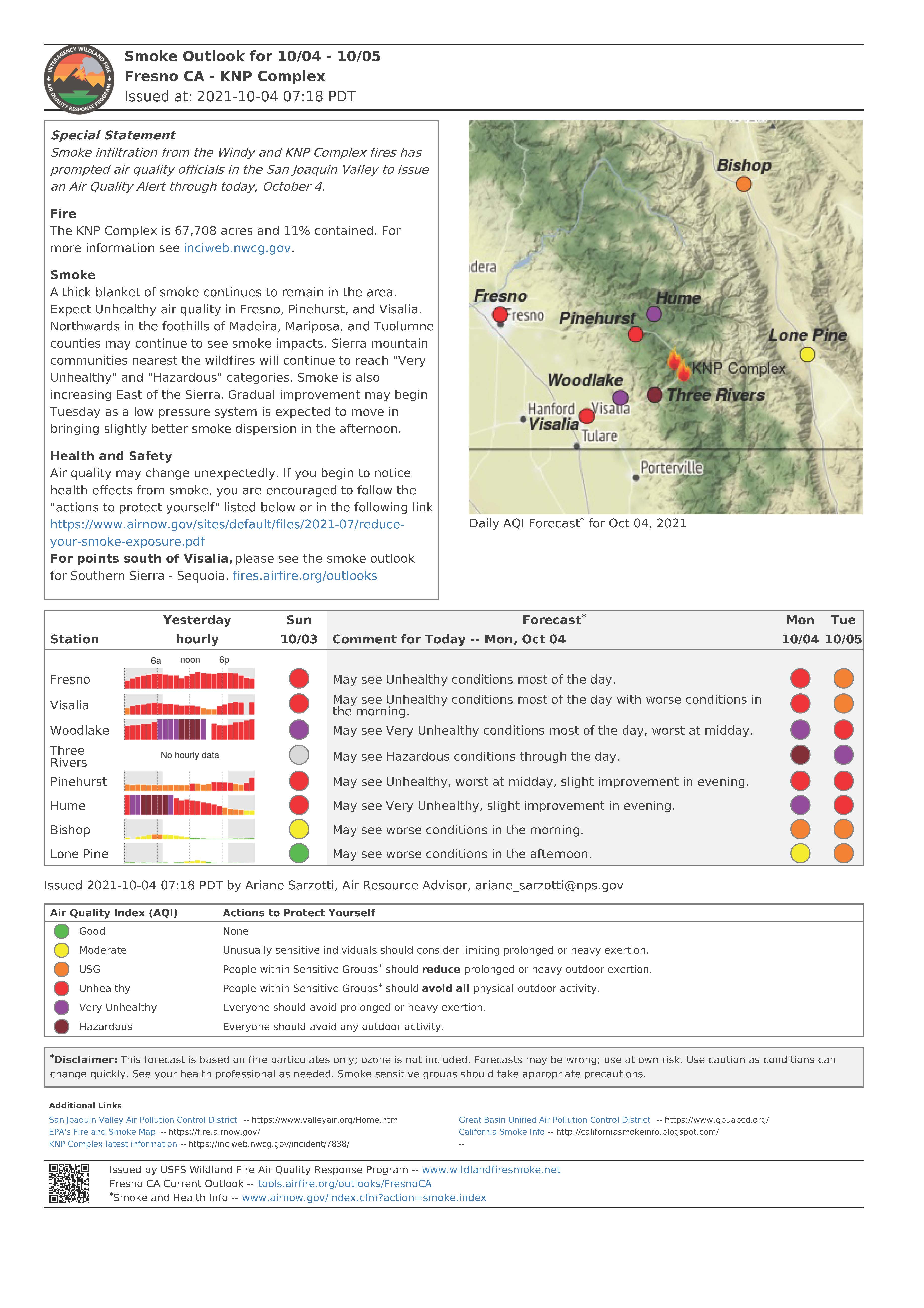
Communities surrounding the park and in the nearby region are being affected by smoke and the resulting poor air quality. Track your local air quality at https://www.wildlandfiresmoke.net/outlooks/FresnoCA.
Fire Information:
PUBLIC: (559) 492-9988 (8 a.m. – 8 p.m.); MEDIA: (559) 492-9967
EMAIL: 2021.KNP@firenet.gov
INCIWEB: https://inciweb.nwcg.gov/incident/7838/
FACEBOOK:
https://www.facebook.com/sequoiakingsnps/
https://www.facebook.com/sequoiaNF/
INSTAGRAM:
https://www.instagram.com/Sequoiakingsnps
https://www.instagram/sequoianationalforest
TWITTER:
https://twitter.com/SequoiaKingsnps
https://twitter.com/sequoiaforest