
? EMERGENCY CLOSURE ? SR-178 has a lane closure when traveling through Kern Canyon between Bakersfield and Lake Isabella. Expect 10-to-15-minute delays. You can always check the Caltrans QuickMap app for real-time conditions.
Spanish: Por favor haga clic aquí Para información en Español
Media: Please view our shared media files (video, photos) on Dropbox.
"Of all the mountain ranges I have climbed; I like the Sierra Nevada the best."
- John Muir
Forest Conditions: Know Before You Go!
A well-planned outing can make the difference between a life-long memory and a disaster you hope to forget as soon as possible. Beautiful, sunny conditions where you live won't necessarily guarantee you the same when you're planning to hike a trail that's located at an elevation above 5000 feet.
The Sequoia National Forest is reminding people to exercise caution when recreating along the many streams, rivers, or lakes in the forest. Significant snowmelt is occurring with warmer temperatures, and streams are running faster and colder than at this time last year. Swimming in flood impacted stream is inherently dangerous. Water-based recreation safety tips.
On May 4, 2023, Tulare County Sheriff Mike Boudreaux issued a temporary river closure for parts of the Kaweah, Kern and Tule rivers. Sections of the Kings and St. John’s rivers are already closed to the public. Kern River white-water rapid enthusiasts can enjoy the excitement, but only with the help of Kern River outfitters.
Current conditions of Recreation Site & Roads / Trails
For detailed descriptions and the current status of the recreational opportunities on the Sequoia National Forest, please visit the Sequoia National Forest - Recreation (usda.gov).
Hume Lake District - Ph.1-559-338-2251
Recreational Site Status Report as of June 1(pdf).
Road Repair Status Map (pdf) - Road surveys and repair is ongoing.
Open roads include Highway 180 to the Hume Lake Junction, Chicago Stump, Millwood OHV and approximately eight miles of the northern portion of Generals Highway. Campgrounds that are open for reservation this weekend are the Hume Lake Campground, Tenmile Campground, Princess Campground, and Aspen Hollow Group campground
Kern River District - Ph.1-760-376-3781
Recreational Site Status Report as of June 1.
Road Repair Status Map (pdf) - Road surveys and repair is ongoing.
The Kern River Ranger District has campgrounds available for public use around Isabella Lake and the Kern Plateau. View the Status Report above for details.
Western Divide District - Ph.1-559-539-2607
Recreational Site Status Report as of June 1(pdf).
Road Repair Status Map (pdf). Road surveys and repair is ongoing.
The iconic Trail of 100 Giants is open, however, it is not accessible from Springville this summer due to storm damage-related closures of Highway 190. Instead, visitors can travel through California Hot Springs, Kernville, and Johnsondale to reach this popular destination site.
Redwood Meadow Campground (near Trail of 100 Giants) and Long Meadow (group only) Campground is now open. Other developed campgrounds: Quaking Aspen and Holey Meadow will tentatively open in mid-June, further delayed by weather conditions.
If you have any questions not answered through these links, please contact your District Ranger Station, Monday thru Friday from 8 am to 4:30 pm.
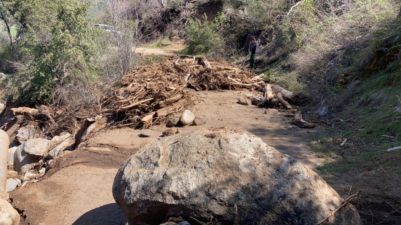
Road Damage Assessments -
Much of the damage assessment and repair on the Sequoia National Forest are being completed by Forest Service employees. Under the umbrella of an Incident Management Organization (IMO), teams of drivers are systematically driving forest roads and assessing damage to roads, recreation sites, or OHV trails. Once located, the sites are turned over to other staff within the IMO equipped with chainsaws and shovels for fallen tree removal or to staff with back-hoe tractors, tracked excavators, and dump trucks. These equipment operators are smoothing out roads, filling erosion holes, cleaning debris from culverts, and generally doing what they can to fix the roads in a timely manner. Damaged sections that require a more substantial repair will be contracted through the Forest Engineer for more specialized contractors to completion. Larger equipment has been requested to assist with road repairs.
Winter Road Closures
A forest closure order remains in effect through June 15th for the Western Divide and Kern River Ranger Districts of the Sequoia National Forest. Full details available on the Sequoia National Forest Website. These closures are designed to help protect road surfaces and natural resources. Please help us protect forest roads and reduce maintenance costs by adhering to the seasonal closures.
Mountain Driving Safety for State and Forest Service Roads
- SLOW DOWN! Use extreme caution if you drive to mountain areas.
- Many areas including campgrounds and trailheads have not melted or remain wet and muddy.
- Watch for falling trees, downed power lines, and rock and debris flows. These may occur suddenly and with little warning.
- If you encounter flooded roads, Turn Around, Don’t Drown! Public Safety Announcement (Youtube) (National Weather Service.)
Hydrology Condition - Upper Kern Watershed as of 06/4/2023
Water Year to Date: 51.18"
% of Average: 182%
Precipitation % of average for full water year through September 30th: 171%
Current Conditions for the Kern River Basin (and other watersheds) are available at California Water Watch
Current Snow Depth (updated daily) for the Southern Sierras is available from the National Oceanic and Atmospheric Administration. Current Estimated Snow Depth(map). Snow depth in the southern sierras is still estimated at up to 200", depending on slope and aspect.
Visit www.recreateresponsibly.org to learn more and follow #RecreateResponsibly on social media. Please visit our website at https://www.fs.usda.gov/sequoia/, email SM.FS.SequoiaNF@usda.gov, and follow the Sequoia National Forest on Facebook @SequoiaNF.
| Current as of | Sat, 10/14/2023 - 19:17 |
|---|---|
| Incident Type | Flood |
| Cause | Significant Winter Rain and Snow. |
| Date of Origin | |
| Location | Sequoia National Forest |
| Incident Commander | Sequoia National Forest |
| Incident Description | Managing recreation access due flooding and road damage on Forest Roads and Recreation Areas. |
| Coordinates |
36° 15' 25'' Latitude
-118° 24' 13
'' Longitude
|
| Significant Events | Forest Service Staff is continuing to assess road conditions across the forest as conditions allow. Larger heavy equipment has been requested to facilitate road repairs however it has been difficult to get these requests filled. Communications with Recreation Service Staff to determine what recreation sites will be safe to open as snow melts and damage is repaired. Many sites remain snow covered and are not accessible or need repairs before opening. |
|---|
| Projected Incident Activity |
Continue to assess and inventory roads. Ongoing snow melt is slowly allowing more roads to be surveyed for damage. Damage repair is continuing where possible. |
|---|
| Weather Concerns | A warming trend is expected to continue today. This afternoon, high temperatures will be around seven to ten degrees above seasonal average. A few strong thunderstorms are possible this afternoon and evening once again today in the Sierra Nevada and adjacent foothills. A storm system will move over Southern California beginning Monday that will provide at least a cooling trend and increased winds in some areas. |
|---|