
Single Publication
Could not determine your location.
 Wildfire
 Prescribed Fire
 Burned Area
Response
Burned Area
Response Other
Other
Cedar Creek Fire Update October 2, 2022
Cedar Creek Fire
Publication Type: News 10/02/2022
Cedar Creek Fire
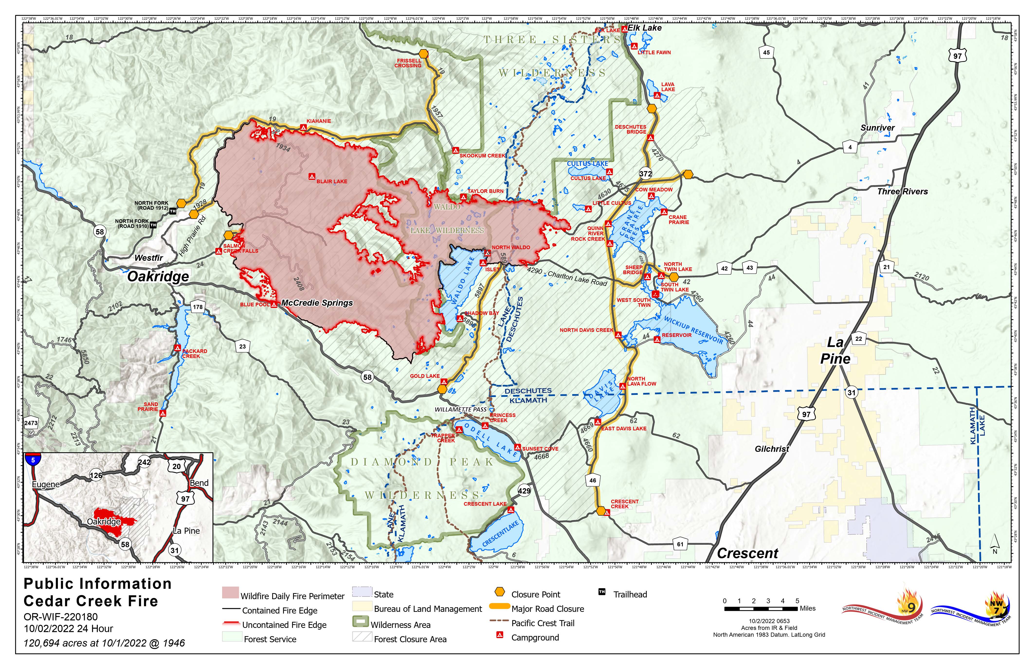
October 2, 2022 | Update 8:30 AM | Size: 120,695 acres | Contained: 27% | Start Date: August 1,2022 | Origin: 15 miles east of Oakridge, OR
Cause: Lightning | Total personnel: 991 | Resources: 21 engines; 18 crews; 17 heavy equipment; 8 helicopters
Deer season opened across the State of Oregon. The Willamette National Forest and the Deschutes National Forest both have closures and fire restrictions in effect for the Cedar Creek Fire. These closures impact hunting units within the fire area and will be enforced.
West Zone Operations: Firefighters were able to remain engaged yesterday as an east wind pushed across the fire area. With the assistance of the Union Pacific Fire Train, crews increased the security of control lines in the south and southwest. The east wind event will continue today but begin to diminish and ultimately shift to a northwest wind by the afternoon and evening. Road grading has begun on the west side of the fire and is expected to continue as crews work to repair areas impacted by firefighting efforts. The southeast area of the fire showed little activity from a reconnaissance flight yesterday afternoon and will continue to be monitored. Work to reduce fuels and repair impacted areas along the northern edge is nearing completion.
East Zone Operations: Yesterday’s work around the divisions east of the crest included processing fuels, skidding, hauling, decking, masticating, and looking ahead to repair work. Some of the road work included identifying areas along the 46 road that need repair and finishing grading along the 700 road near Cultus Lake. Temperatures are unseasonably hotter and drier than normal with no precipitation in the foreseeable forecast. The fire is expected to continue creeping and smoldering, but no spotting is anticipated.
Weather: Temperatures will be rising again today with the continued east winds. Winds will shift to a westerly direction in the afternoon, but temperatures will remain in the high 70s to 80s for the coming week
Closures: The Deschutes National Forest and Willamette National Forest both have closures and fire restrictions in effect. Some of these closures will remain in effect until areas that have been heavily impacted by the fire are surveyed for safety hazards. Please respect Forest closures for firefighter and public safety. Violations of these prohibitions are punishable by a fine of not more than $5,000.00 for an individual or $10,000.00 for a corporation or imprisonment for not more than six months or both. 16 USC § 551 and 18 U.S.C §§ 3551, 3559, 3571, and 3581. Please visit Willamette National Forest and Deschutes National Forest for the most recent closure orders and maps. A Temporary Flight Restriction (TFR) is in place. The use of drones is prohibited in the fire area, please make it safe for our firefighters to use aircraft on the fire. Pacific Crest Trail hikers should visit pcta.org for current information.
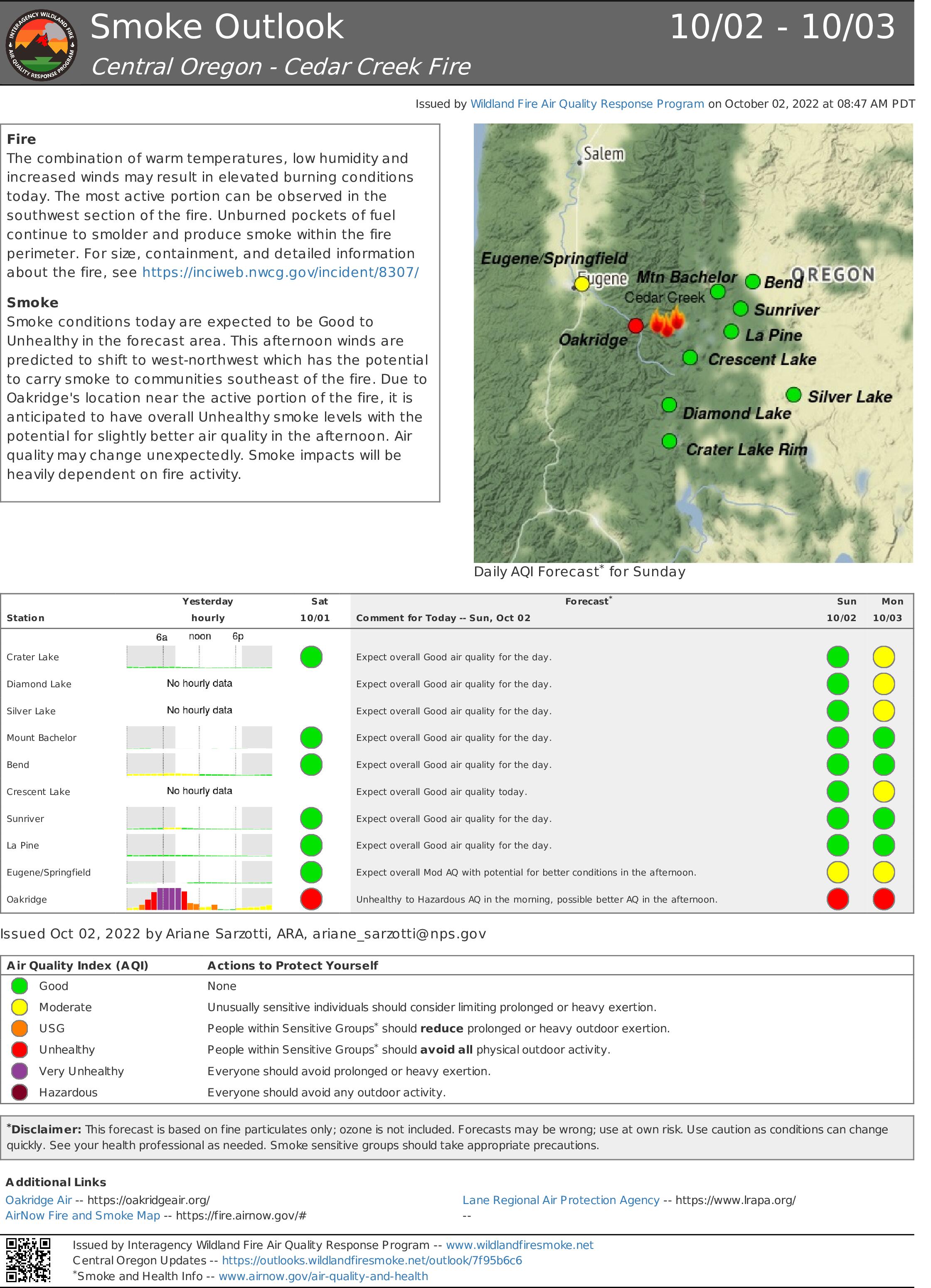
Smoke: For current conditions, see Fire.airnow.gov, oakridgeair.org, and LRAPA - Today's Current Air Quality. Smoke Forecast Outlooks are available at https://outlooks.wildlandfiresmoke.net/outlook.
Evacuations: An updated map of the evacuation areas is available at www.LaneCountyOR.gov/CedarCreek. Sign-up for emergency mobile alerts by going to oralert.gov. Please check with Lane County Sheriff’s Office at 541-682-4150 and Deschutes County Sheriff’s Office at 541-693-6911 for updates and changes.