
Sunday morning October 23, Rocky Mountain Incident Management Team Three assumed command of the Goat Rocks Fire, to continue the great work done by the type 3 organization. The Rocky Mountain IMT is also managing the Siouxon and Sunset fires to the southwest on the Gifford Pinchot National Forest. On Saturday, October 29, Rocky Mountain CIMT will return management of the Goat Rocks, Siouxon and Sunset fires to the Gifford Pinchot National Forest.
Resources:
Daily Fire Updates can be accessed here or through the News tab in the blue bar located in the upper portion of this page.
A variety of maps are added daily to the Maps section in the blue bar in the upper portion of this page or via this direct link.
History and Command
On September 12, Northwest Incident Management Team 10 took command of the Goat Rocks Fire. They did extensive work on the fire before passing management to Nevada Incident Management Team 4 on September 25.
Another Type 3 Incident Management Team assumed command of the fire on October 9, 2022. They continued work to contain the fire and started suppression repair work before passing management to Rocky Mountain Incident Management Team Three on October 23. On October 28, management of the Goat Rocks Fire returns to the Gifford Pinchot National Forest.
| Current as of | Mon, 11/14/2022 - 17:55 |
|---|---|
| Incident Type | Wildfire |
| Cause | Lightning |
| Date of Origin | |
| Location | Packwood, Washington |
| Incident Commander | Bill Waln, Incident Commander, Rocky Mountain Area Incident Management Team Three |
| Incident Description | A wildfire burning in steep terrain and dense forests in and around the Goat Rocks Wilderness. |
| Coordinates |
46° 38' 8'' Latitude
-121° 31' 2
'' Longitude
|
| Total Personnel: | 125 |
|---|---|
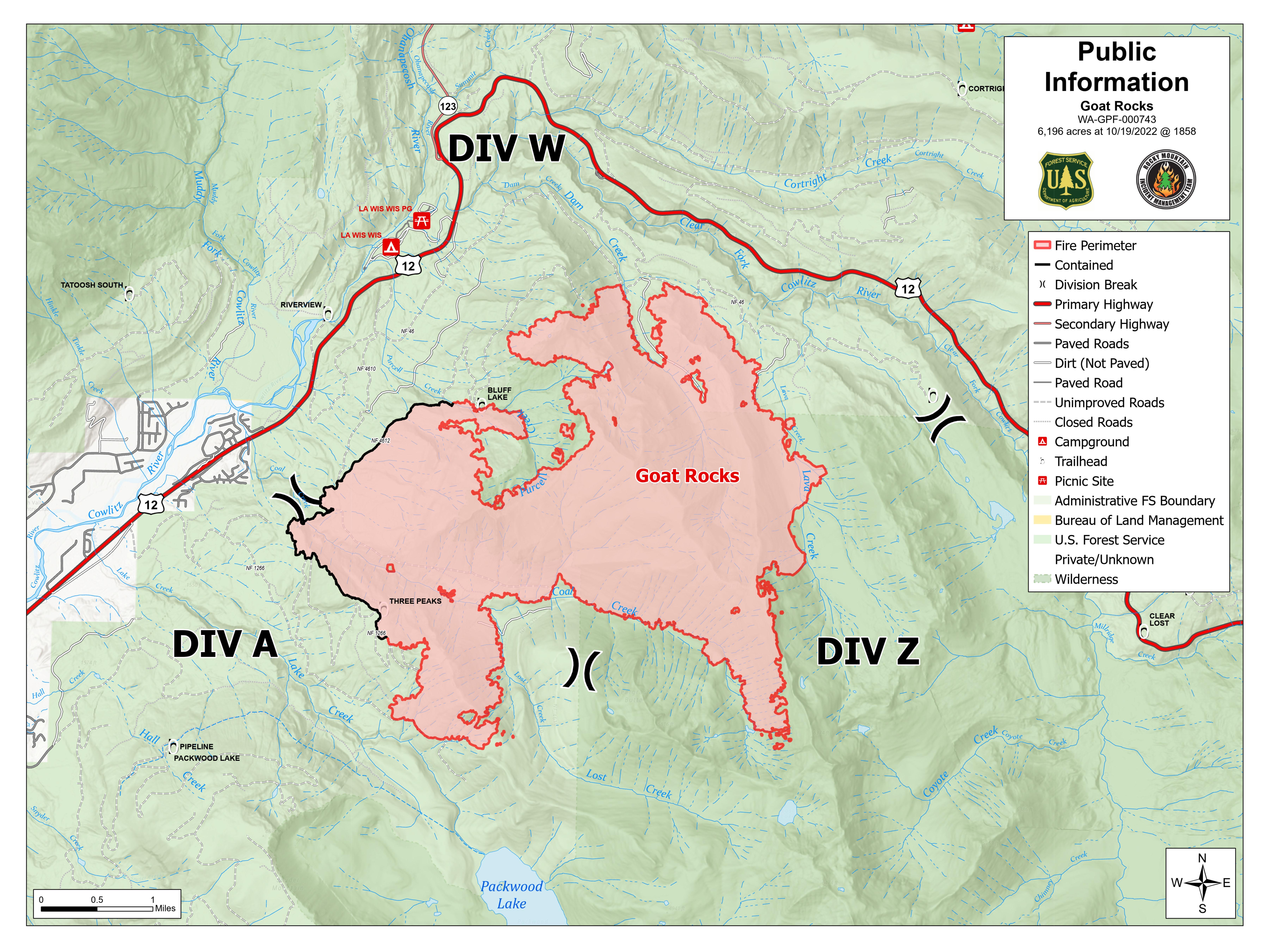
| Size | 6,196 Acres |
| Percent of Perimeter Contained | 66% |
| Estimated Containment Date | 2022-11-01 17:00:00 |
| Fuels Involved | Timber (Grass and Understory) Closed Timber Litter Brush (2 feet) Mixed conifer timber stands composed of Douglas-fir, Western Hemlock, and scattered Western Red Cedar. Young stands of Douglas-fir plantations are found scattered in and around the fire area. All fuels are very receptive to fire spread due to fuel moisture being much below seasonal averages. |
| Significant Events | Creeping/smoldering. Scattered heat. Minimal surface fire activity. |
| Planned Actions |
Div A - Monitor fire growth in Coal Creek and Lake Creek drainages. Scouting and looking for opportunities to hold the fire on Three Peaks ridge system as it comes out of Coal Creek drainage. Scouting contingency line opportunities on the south side of Lake Creek drainage. Removing activity fuels from the 41 Road. Patrol the 41 Road and take suppression actions where necessary. Continue to patrol structures at Packwood Lake, and assess fire behavior in the Coal Creek drainage. Prepare for structure protection. Hose removal and suppression repair complete. Div W - Monitor fire spread east of the 4612 Road. Monitor fire spread in Dam Creek down to the 46 Road. Continue to patrol structures in the Goat Rocks, Lower Timberline, Upper Timberline, Riverdance and Coal Creek subdivisions, interact with homeowners, and look for areas to improve structure preparation. Ensure engine crews are familiarized with the coordinated response plan. |
|---|---|
| Projected Incident Activity |
Minimal fire activity with creeping and smoldering. No growth is expected. |
| Remarks |
Fire is being managed by Rocky Mountain Complex Incident Management Team Three. |
| Weather Concerns | Partly cloudy and cool. Snow level at 5,000'. High temperatures between 40 and 50 degrees Fahrenheit. South winds 4-6 mph. Minimum relative humidity values are expected to remain above 55%. |
|---|